Jumilla elevation
Jumilla (Murcia), Spain elevation is 527 meters and Jumilla elevation in feet is 1729 ft above sea level [src 1]. Jumilla is a seat of a third-order administrative division (feature code) with elevation that is 76 meters (249 ft) smaller than average city elevation in Spain.
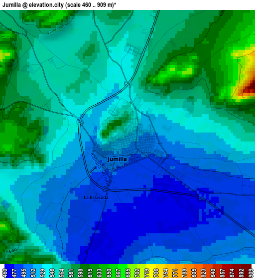
Below is the Elevation map of Jumilla, which displays elevation range with different colors. Scale of the first map is from 460 to 909 m (1509 to 2982 ft) with average elevation of 543.6 meters (=1783 ft) [note 1]
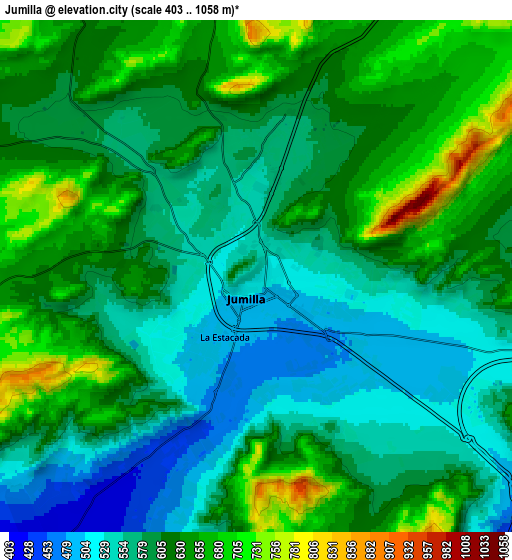
These maps also provides idea of topography and contour of this city, they are displayed at different zoom levels. More info about maps, scale and edge coordinates you can find below images.
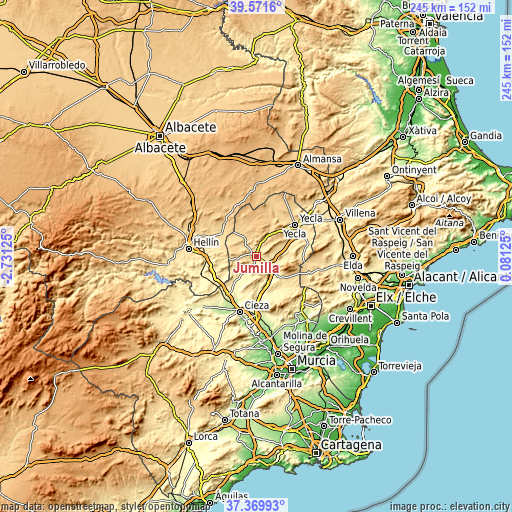
| \ | Map #1 | Map #2 | Topo.Map |
| Scale [m] | 460..909 m | 403..1058 m | × |
| Scale [ft] | 1509..2982 ft | 1322..3471 ft | × |
| Average | 543.6 m = 1783 ft | 602 m = 1975 ft | × |
| Width | 7.65 km = 4.8 mi | 15.3 km = 9.5 mi | 244.8 km = 152.1 mi |
| Height | 7.65 km = 4.8 mi | 15.3 km = 9.5 mi | 244.8 km = 152.1 mi |
| ↑Max Latitude | 38.513564° | 38.547941° | 39.5716° |
| Latitude at center | 38.47917° | 38.47917° | 38.47917° |
| ↓Min Latitude | 38.44476° | 38.410333° | 37.36993° |
| ← Min Longitude | -1.368945° | -1.412891° | -2.73125° |
| Longitude center | -1.325° | -1.325° | -1.325° |
| →Max Longitude | -1.281055° | -1.237109° | 0.08125° |
Nearby cities:
Cities around Jumilla sort by population:
• Cieza elevation 194 m
27.9 km,  197°
197°
• Yecla 620 m
23.6 km,  50°
50°
• Hellín 557 m
32.9 km,  276°
276°
• Abarán 188 m
31.1 km,  191°
191°
• Tobarra 650 m
34.3 km,  291°
291°
• Pinoso 573 m
26.1 km,  109°
109°
• Blanca 151 m
33.6 km, 187°
• Fuente-Álamo 825 m
25.5 km,  338°
338°
• Ontur 662 m
21.3 km,  315°
315°
• Montealegre del Castillo 803 m
34.4 km,  359°
359°
• Algueña 537 m
32 km,  119°
119°
• Albatana 584 m
19.9 km,  300°
300°
Multilingual:
 En español:
Jumilla elevación 527 m.
 En France:
Jumilla élévation 527 m.


Sources and notes:
- [note 1] Map square and city borders are not equal. Map elevation data is calculated only from area inside that square.
- [src 1] Elevation data from geonames database provided with same terms of usage.
- [src 2] The elevation map of Jumilla is generated using elevation data from NASA's 3 arcsec (90m) resolution SRTM data.
- [src 3] Base (background) map © OpenStreetMap contributors tiles are generated by Geofabrik and OpenTopoMap.
Copyright & License:
This Jumilla Elevation Map is licensed under CC BY-SA. You may reuse any part from this page, if you give a proper credit by linking to this URL:
 More info on terms of use page.