Pinoso elevation
Pinoso (Valencia, Provincia de Alicante), Spain elevation is 573 meters and Pinoso elevation in feet is 1880 ft above sea level [src 1]. Pinoso is a populated place (feature code) with elevation that is 30 meters (98 ft) smaller than average city elevation in Spain.
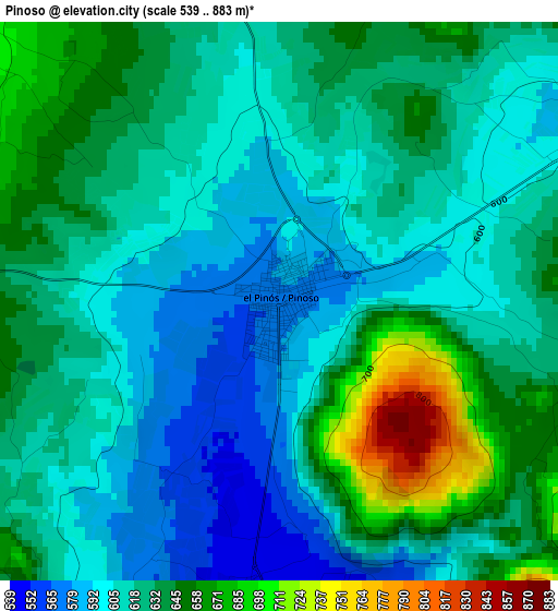
Below is the Elevation map of Pinoso, which displays elevation range with different colors. Scale of the first map is from 539 to 883 m (1768 to 2897 ft) with average elevation of 622.7 meters (=2043 ft) [note 1]
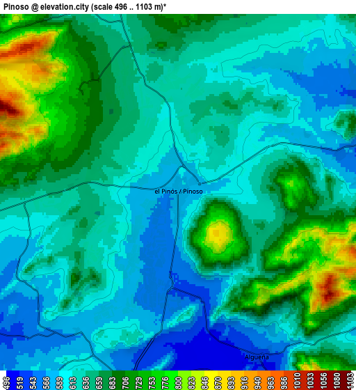
These maps also provides idea of topography and contour of this city, they are displayed at different zoom levels. More info about maps, scale and edge coordinates you can find below images.
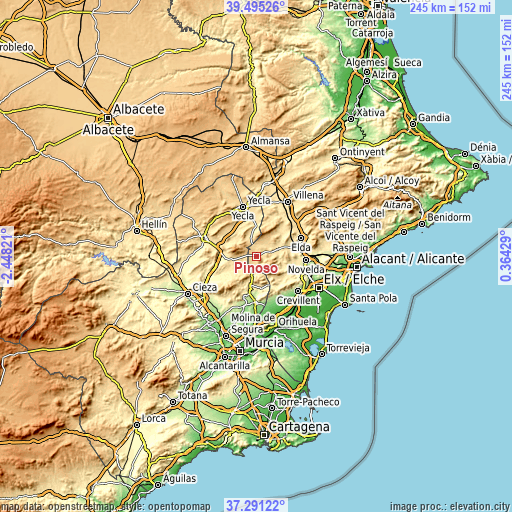
| \ | Map #1 | Map #2 | Topo.Map |
| Scale [m] | 539..883 m | 496..1103 m | × |
| Scale [ft] | 1768..2897 ft | 1627..3619 ft | × |
| Average | 622.7 m = 2043 ft | 646 m = 2119 ft | × |
| Width | 7.66 km = 4.8 mi | 15.32 km = 9.5 mi | 245.1 km = 152.3 mi |
| Height | 7.66 km = 4.8 mi | 15.32 km = 9.5 mi | 245.1 km = 152.3 mi |
| ↑Max Latitude | 38.436071° | 38.470485° | 39.49526° |
| Latitude at center | 38.40164° | 38.40164° | 38.40164° |
| ↓Min Latitude | 38.367193° | 38.332729° | 37.29122° |
| ← Min Longitude | -1.085905° | -1.129851° | -2.44821° |
| Longitude center | -1.04196° | -1.04196° | -1.04196° |
| →Max Longitude | -0.998015° | -0.954069° | 0.36429° |
Nearby cities:
Cities around Pinoso sort by population:
• Elda elevation 412 m
23.4 km,  68°
68°
• Yecla 620 m
24.4 km,  344°
344°
• Novelda 247 m
24 km,  94°
94°
• Aspe 245 m
24.8 km,  104°
104°
• Monóvar 406 m
18 km,  76°
76°
• Sax 480 m
24.7 km,  52°
52°
• Abanilla 207 m
21.8 km,  179°
179°
• La Romana 429 m
13.1 km,  106°
106°
• Hondón de las Nieves 376 m
19.4 km,  122°
122°
• Algueña 537 m
7.7 km,  154°
154°
• Salinas 491 m
17.4 km,  40°
40°
• Hondón de los Frailes 423 m
17.3 km, 145°
Multilingual:
 En español:
Pinoso elevación 573 m.
 En France:
El Pinós élévation 573 m.


Sources and notes:
- [note 1] Map square and city borders are not equal. Map elevation data is calculated only from area inside that square.
- [src 1] Elevation data from geonames database provided with same terms of usage.
- [src 2] The elevation map of Pinoso is generated using elevation data from NASA's 3 arcsec (90m) resolution SRTM data.
- [src 3] Base (background) map © OpenStreetMap contributors tiles are generated by Geofabrik and OpenTopoMap.
Copyright & License:
This Pinoso Elevation Map is licensed under CC BY-SA. You may reuse any part from this page, if you give a proper credit by linking to this URL:
 More info on terms of use page.