Pozo-Cañada elevation
Pozo-Cañada (Castille-La Mancha, Provincia de Albacete), Spain elevation is 811 meters and Pozo-Cañada elevation in feet is 2661 ft above sea level [src 1]. Pozo-Cañada is a populated place (feature code) with elevation that is 208 meters (682 ft) bigger than average city elevation in Spain.
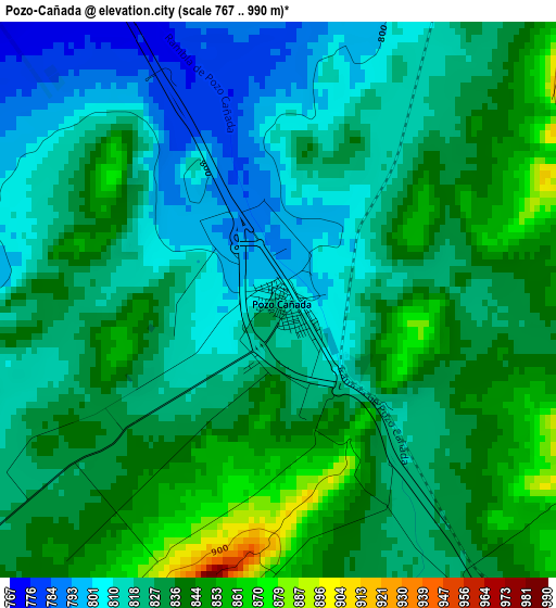
Below is the Elevation map of Pozo-Cañada, which displays elevation range with different colors. Scale of the first map is from 767 to 990 m (2516 to 3248 ft) with average elevation of 827.7 meters (=2716 ft) [note 1]
These maps also provides idea of topography and contour of this city, they are displayed at different zoom levels. More info about maps, scale and edge coordinates you can find below images.
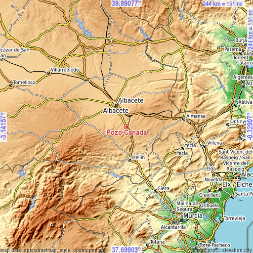
| \ | Map #1 | Topo.Map |
| Scale [m] | 767..990 m | × |
| Scale [ft] | 2516..3248 ft | × |
| Average | 827.7 m = 2716 ft | × |
| Width | 7.62 km = 4.7 mi | 243.7 km = 151.4 mi |
| Height | 7.62 km = 4.7 mi | 243.7 km = 151.4 mi |
| ↑Max Latitude | 38.837568° | 39.89077° |
| Latitude at center | 38.80333° | 38.80333° |
| ↓Min Latitude | 38.769075° | 37.69903° |
| ← Min Longitude | -1.779265° | -3.14157° |
| Longitude center | -1.73532° | -1.73532° |
| →Max Longitude | -1.691375° | -0.32907° |
Nearby cities:
Cities around Pozo-Cañada sort by population:
• Albacete elevation 695 m
23.7 km,  333°
333°
• Tobarra 650 m
23.8 km,  170°
170°
• Chinchilla de Monte Aragón 889 m
13.1 km,  5°
5°
• Fuente-Álamo 825 m
29.1 km,  114°
114°
• Ontur 662 m
29.4 km,  135°
135°
• Pozohondo 871 m
17.8 km,  239°
239°
• Higueruela 1019 m
30.9 km,  54°
54°
• Peñas de San Pedro 1028 m
24.8 km,  250°
250°
• Hoya-Gonzalo 935 m
23.1 km,  41°
41°
• Pétrola 870 m
15.7 km,  80°
80°
• Alcadozo 927 m
27.3 km,  231°
231°
• Corral-Rubio 875 m
24.1 km, 81°
Multilingual:
 En español:
Pozo-Cañada elevación 811 m.
 En France:
Pozo-Cañada élévation 811 m.
 Auf Deutsch:
Pozo-Cañada höhe über dem Meeresspiegel ist 811 m.

Sources and notes:
- [note 1] Map square and city borders are not equal. Map elevation data is calculated only from area inside that square.
- [src 1] Elevation data from geonames database provided with same terms of usage.
- [src 2] The elevation map of Pozo-Cañada is generated using elevation data from NASA's 3 arcsec (90m) resolution SRTM data.
- [src 3] Base (background) map © OpenStreetMap contributors tiles are generated by Geofabrik and OpenTopoMap.
Copyright & License:
This Pozo-Cañada Elevation Map is licensed under CC BY-SA. You may reuse any part from this page, if you give a proper credit by linking to this URL:
 More info on terms of use page.