Peñas de San Pedro elevation
Peñas de San Pedro (Castille-La Mancha, Provincia de Albacete), Spain elevation is 1028 meters and Peñas de San Pedro elevation in feet is 3373 ft above sea level [src 1]. Peñas de San Pedro is a seat of a third-order administrative division (feature code) with elevation that is 425 meters (1394 ft) bigger than average city elevation in Spain.
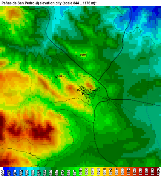
Below is the Elevation map of Peñas de San Pedro, which displays elevation range with different colors. Scale of the first map is from 844 to 1176 m (2769 to 3858 ft) with average elevation of 981.6 meters (=3220 ft) [note 1]
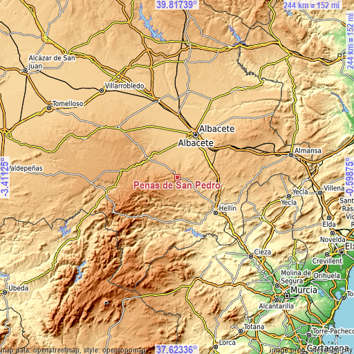
These maps also provides idea of topography and contour of this city, they are displayed at different zoom levels. More info about maps, scale and edge coordinates you can find below images.
| \ | Map #1 | Topo.Map |
| Scale [m] | 844..1176 m | × |
| Scale [ft] | 2769..3858 ft | × |
| Average | 981.6 m = 3220 ft | × |
| Width | 7.62 km = 4.7 mi | 244 km = 151.6 mi |
| Height | 7.62 km = 4.7 mi | 243.9 km = 151.6 mi |
| ↑Max Latitude | 38.763074° | 39.81739° |
| Latitude at center | 38.7288° | 38.7288° |
| ↓Min Latitude | 38.694509° | 37.62336° |
| ← Min Longitude | -2.048945° | -3.41125° |
| Longitude center | -2.005° | -2.005° |
| →Max Longitude | -1.961055° | -0.59875° |
Nearby cities:
Cities around Peñas de San Pedro sort by population:
• Tobarra elevation 650 m
31.1 km,  119°
119°
• Pozo-Cañada 811 m
24.8 km,  70°
70°
• Balazote 779 m
21.5 km,  323°
323°
• Pozohondo 871 m
8.1 km,  96°
96°
• Liétor 672 m
21.2 km,  167°
167°
• San Pedro 838 m
18.8 km,  304°
304°
• Bogarra 853 m
24.4 km,  227°
227°
• Ayna 712 m
21 km,  198°
198°
• Alcadozo 927 m
9.1 km, 166°
• Pozuelo 848 m
12.3 km, 317°
• Casas de Lázaro 950 m
20.9 km,  282°
282°
• Masegoso 1107 m
27 km,  267°
267°
Multilingual:
 En español:
Peñas de San Pedro elevación 1028 m.
 En France:
Peñas de San Pedro élévation 1028 m.
 Auf Deutsch:
Peñas de San Pedro höhe über dem Meeresspiegel ist 1028 m.
 На русском:
Peñas de San Pedro высота над уровнем моря 1028 м
Sources and notes:
- [note 1] Map square and city borders are not equal. Map elevation data is calculated only from area inside that square.
- [src 1] Elevation data from geonames database provided with same terms of usage.
- [src 2] The elevation map of Peñas de San Pedro is generated using elevation data from NASA's 3 arcsec (90m) resolution SRTM data.
- [src 3] Base (background) map © OpenStreetMap contributors tiles are generated by Geofabrik and OpenTopoMap.
Copyright & License:
This Peñas de San Pedro Elevation Map is licensed under CC BY-SA. You may reuse any part from this page, if you give a proper credit by linking to this URL:
 More info on terms of use page.