Alcadozo elevation
Alcadozo (Castille-La Mancha, Provincia de Albacete), Spain elevation is 927 meters and Alcadozo elevation in feet is 3041 ft above sea level [src 1]. Alcadozo is a seat of a third-order administrative division (feature code) with elevation that is 324 meters (1063 ft) bigger than average city elevation in Spain.
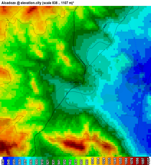
Below is the Elevation map of Alcadozo, which displays elevation range with different colors. Scale of the first map is from 838 to 1107 m (2749 to 3632 ft) with average elevation of 937.8 meters (=3077 ft) [note 1]
These maps also provides idea of topography and contour of this city, they are displayed at different zoom levels. More info about maps, scale and edge coordinates you can find below images.
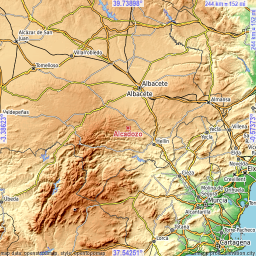
| \ | Map #1 | Topo.Map |
| Scale [m] | 838..1107 m | × |
| Scale [ft] | 2749..3632 ft | × |
| Average | 937.8 m = 3077 ft | × |
| Width | 7.63 km = 4.7 mi | 244.2 km = 151.7 mi |
| Height | 7.63 km = 4.7 mi | 244.2 km = 151.7 mi |
| ↑Max Latitude | 38.683472° | 39.73898° |
| Latitude at center | 38.64916° | 38.64916° |
| ↓Min Latitude | 38.614831° | 37.54251° |
| ← Min Longitude | -2.023925° | -3.38623° |
| Longitude center | -1.97998° | -1.97998° |
| →Max Longitude | -1.936035° | -0.57373° |
Nearby cities:
Cities around Alcadozo sort by population:
• Hellín elevation 557 m
28.7 km,  122°
122°
• Tobarra 650 m
25.8 km,  104°
104°
• Elche de la Sierra 642 m
22.8 km,  194°
194°
• Pozo-Cañada 811 m
27.3 km,  51°
51°
• Pozohondo 871 m
9.9 km,  36°
36°
• Liétor 672 m
12.1 km,  169°
169°
• San Pedro 838 m
26.3 km,  318°
318°
• Peñas de San Pedro 1028 m
9.1 km,  346°
346°
• Bogarra 853 m
21.6 km,  249°
249°
• Ayna 712 m
14.2 km,  219°
219°
• Pozuelo 848 m
20.7 km,  329°
329°
• Casas de Lázaro 950 m
26.3 km,  300°
300°
Multilingual:
 En español:
Alcadozo elevación 927 m.
 En France:
Alcadozo élévation 927 m.
 Auf Deutsch:
Alcadozo höhe über dem Meeresspiegel ist 927 m.

Sources and notes:
- [note 1] Map square and city borders are not equal. Map elevation data is calculated only from area inside that square.
- [src 1] Elevation data from geonames database provided with same terms of usage.
- [src 2] The elevation map of Alcadozo is generated using elevation data from NASA's 3 arcsec (90m) resolution SRTM data.
- [src 3] Base (background) map © OpenStreetMap contributors tiles are generated by Geofabrik and OpenTopoMap.
Copyright & License:
This Alcadozo Elevation Map is licensed under CC BY-SA. You may reuse any part from this page, if you give a proper credit by linking to this URL:
 More info on terms of use page.