Pozuelo elevation
Pozuelo (Castille-La Mancha, Provincia de Albacete), Spain elevation is 848 meters and Pozuelo elevation in feet is 2782 ft above sea level [src 1]. Pozuelo is a seat of a third-order administrative division (feature code) with elevation that is 245 meters (804 ft) bigger than average city elevation in Spain.
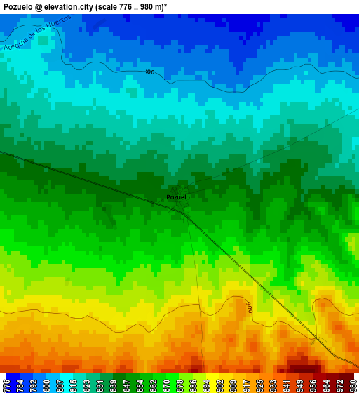
Below is the Elevation map of Pozuelo, which displays elevation range with different colors. Scale of the first map is from 776 to 980 m (2546 to 3215 ft) with average elevation of 851.4 meters (=2793 ft) [note 1]
These maps also provides idea of topography and contour of this city, they are displayed at different zoom levels. More info about maps, scale and edge coordinates you can find below images.
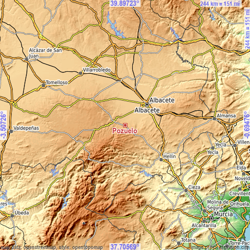
| \ | Map #1 | Topo.Map |
| Scale [m] | 776..980 m | × |
| Scale [ft] | 2546..3215 ft | × |
| Average | 851.4 m = 2793 ft | × |
| Width | 7.61 km = 4.7 mi | 243.7 km = 151.4 mi |
| Height | 7.62 km = 4.7 mi | 243.7 km = 151.4 mi |
| ↑Max Latitude | 38.844125° | 39.89723° |
| Latitude at center | 38.80989° | 38.80989° |
| ↓Min Latitude | 38.775638° | 37.70569° |
| ← Min Longitude | -2.144955° | -3.50726° |
| Longitude center | -2.10101° | -2.10101° |
| →Max Longitude | -2.057065° | -0.69476° |
Nearby cities:
Cities around Pozuelo sort by population:
• Albacete elevation 695 m
29.5 km,  45°
45°
• Balazote 779 m
9.4 km,  332°
332°
• Barrax 735 m
27.7 km,  341°
341°
• Pozohondo 871 m
19.1 km,  121°
121°
• Lezuza 927 m
26.9 km,  305°
305°
• San Pedro 838 m
7.3 km,  283°
283°
• Peñas de San Pedro 1028 m
12.3 km,  137°
137°
• Bogarra 853 m
27.2 km,  200°
200°
• Ayna 712 m
28.9 km,  176°
176°
• Alcadozo 927 m
20.7 km,  149°
149°
• Casas de Lázaro 950 m
12.9 km,  250°
250°
• Masegoso 1107 m
21.2 km,  241°
241°
Multilingual:
 En español:
Pozuelo elevación 848 m.
 En France:
Pozuelo élévation 848 m.


Sources and notes:
- [note 1] Map square and city borders are not equal. Map elevation data is calculated only from area inside that square.
- [src 1] Elevation data from geonames database provided with same terms of usage.
- [src 2] The elevation map of Pozuelo is generated using elevation data from NASA's 3 arcsec (90m) resolution SRTM data.
- [src 3] Base (background) map © OpenStreetMap contributors tiles are generated by Geofabrik and OpenTopoMap.
Copyright & License:
This Pozuelo Elevation Map is licensed under CC BY-SA. You may reuse any part from this page, if you give a proper credit by linking to this URL:
 More info on terms of use page.