Higueruela elevation
Higueruela (Castille-La Mancha, Provincia de Albacete), Spain elevation is 1019 meters and Higueruela elevation in feet is 3343 ft above sea level [src 1]. Higueruela is a seat of a third-order administrative division (feature code) with elevation that is 416 meters (1365 ft) bigger than average city elevation in Spain.
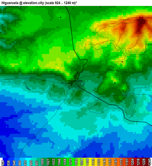
Below is the Elevation map of Higueruela, which displays elevation range with different colors. Scale of the first map is from 924 to 1240 m (3031 to 4068 ft) with average elevation of 1020.9 meters (=3349 ft) [note 1]
These maps also provides idea of topography and contour of this city, they are displayed at different zoom levels. More info about maps, scale and edge coordinates you can find below images.
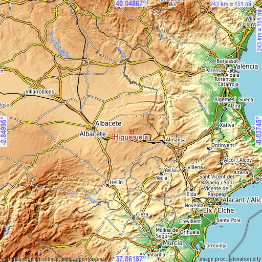
| \ | Map #1 | Topo.Map |
| Scale [m] | 924..1240 m | × |
| Scale [ft] | 3031..4068 ft | × |
| Average | 1020.9 m = 3349 ft | × |
| Width | 7.6 km = 4.7 mi | 243.1 km = 151.1 mi |
| Height | 7.6 km = 4.7 mi | 243.1 km = 151.1 mi |
| ↑Max Latitude | 38.997871° | 40.04867° |
| Latitude at center | 38.96371° | 38.96371° |
| ↓Min Latitude | 38.929532° | 37.86187° |
| ← Min Longitude | -1.487645° | -2.84995° |
| Longitude center | -1.4437° | -1.4437° |
| →Max Longitude | -1.399755° | -0.03745° |
Nearby cities:
Cities around Higueruela sort by population:
• Chinchilla de Monte Aragón elevation 889 m
24.4 km,  258°
258°
• Alpera 814 m
18.4 km,  91°
91°
• Montealegre del Castillo 803 m
21.9 km,  152°
152°
• Casas de Juan Núñez 710 m
18.3 km,  327°
327°
• Bonete 894 m
13.2 km,  141°
141°
• Hoya-Gonzalo 935 m
9.8 km,  266°
266°
• Pétrola 870 m
18.1 km,  212°
212°
• Carcelén 921 m
19.3 km,  37°
37°
• Alatoz 860 m
16.2 km,  26°
26°
• Jorquera 669 m
23.4 km,  344°
344°
• Corral-Rubio 875 m
14.4 km,  185°
185°
• Villavaliente 728 m
18.1 km,  356°
356°
Multilingual:
 En español:
Higueruela elevación 1019 m.
 En France:
Higueruela élévation 1019 m.
 Auf Deutsch:
Higueruela höhe über dem Meeresspiegel ist 1019 m.

Sources and notes:
- [note 1] Map square and city borders are not equal. Map elevation data is calculated only from area inside that square.
- [src 1] Elevation data from geonames database provided with same terms of usage.
- [src 2] The elevation map of Higueruela is generated using elevation data from NASA's 3 arcsec (90m) resolution SRTM data.
- [src 3] Base (background) map © OpenStreetMap contributors tiles are generated by Geofabrik and OpenTopoMap.
Copyright & License:
This Higueruela Elevation Map is licensed under CC BY-SA. You may reuse any part from this page, if you give a proper credit by linking to this URL:
 More info on terms of use page.