Alpera elevation
Alpera (Castille-La Mancha, Provincia de Albacete), Spain elevation is 814 meters and Alpera elevation in feet is 2671 ft above sea level [src 1]. Alpera is a seat of a third-order administrative division (feature code) with elevation that is 211 meters (692 ft) bigger than average city elevation in Spain.
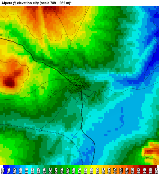
Below is the Elevation map of Alpera, which displays elevation range with different colors. Scale of the first map is from 789 to 962 m (2589 to 3156 ft) with average elevation of 850.1 meters (=2789 ft) [note 1]
These maps also provides idea of topography and contour of this city, they are displayed at different zoom levels. More info about maps, scale and edge coordinates you can find below images.
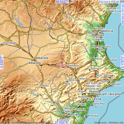
| \ | Map #1 | Topo.Map |
| Scale [m] | 789..962 m | × |
| Scale [ft] | 2589..3156 ft | × |
| Average | 850.1 m = 2789 ft | × |
| Width | 7.6 km = 4.7 mi | 243.2 km = 151.1 mi |
| Height | 7.6 km = 4.7 mi | 243.2 km = 151.1 mi |
| ↑Max Latitude | 38.992824° | 40.0437° |
| Latitude at center | 38.95866° | 38.95866° |
| ↓Min Latitude | 38.92448° | 37.85675° |
| ← Min Longitude | -1.274465° | -2.63677° |
| Longitude center | -1.23052° | -1.23052° |
| →Max Longitude | -1.186575° | 0.17573° |
Nearby cities:
Cities around Alpera sort by population:
• Almansa elevation 702 m
15.2 km,  130°
130°
• Ayora 609 m
18.7 km,  53°
53°
• Montealegre del Castillo 803 m
20.7 km,  203°
203°
• Higueruela 1019 m
18.4 km,  271°
271°
• Bonete 894 m
14.1 km,  226°
226°
• Jarafuel 589 m
24.3 km,  33°
33°
• Carcelén 921 m
17.3 km,  337°
337°
• Alatoz 860 m
18.9 km,  323°
323°
• Zarra 573 m
20 km,  42°
42°
• Corral-Rubio 875 m
24.2 km,  235°
235°
• Villavaliente 728 m
27 km,  313°
313°
• Villa de Ves 674 m
26.8 km,  359°
359°
Multilingual:
 En español:
Alpera elevación 814 m.
 En France:
Alpera élévation 814 m.


Sources and notes:
- [note 1] Map square and city borders are not equal. Map elevation data is calculated only from area inside that square.
- [src 1] Elevation data from geonames database provided with same terms of usage.
- [src 2] The elevation map of Alpera is generated using elevation data from NASA's 3 arcsec (90m) resolution SRTM data.
- [src 3] Base (background) map © OpenStreetMap contributors tiles are generated by Geofabrik and OpenTopoMap.
Copyright & License:
This Alpera Elevation Map is licensed under CC BY-SA. You may reuse any part from this page, if you give a proper credit by linking to this URL:
 More info on terms of use page.