Albuñuelas elevation
Albuñuelas (Andalusia, Provincia de Granada), Spain elevation is 730 meters and Albuñuelas elevation in feet is 2395 ft above sea level [src 1]. Albuñuelas is a seat of a third-order administrative division (feature code) with elevation that is 127 meters (417 ft) bigger than average city elevation in Spain.
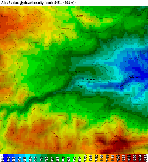
Below is the Elevation map of Albuñuelas, which displays elevation range with different colors. Scale of the first map is from 515 to 1398 m (1690 to 4587 ft) with average elevation of 938.7 meters (=3080 ft) [note 1]
These maps also provides idea of topography and contour of this city, they are displayed at different zoom levels. More info about maps, scale and edge coordinates you can find below images.
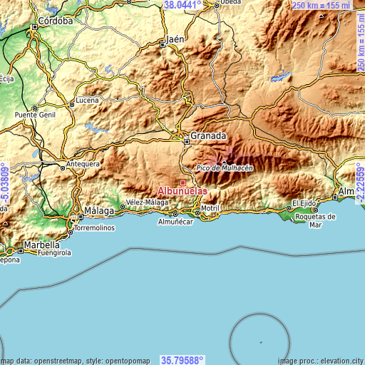
| \ | Map #1 | Topo.Map |
| Scale [m] | 515..1398 m | × |
| Scale [ft] | 1690..4587 ft | × |
| Average | 938.7 m = 3080 ft | × |
| Width | 7.81 km = 4.9 mi | 250 km = 155.3 mi |
| Height | 7.81 km = 4.9 mi | 250 km = 155.3 mi |
| ↑Max Latitude | 36.963401° | 38.0441° |
| Latitude at center | 36.92828° | 36.92828° |
| ↓Min Latitude | 36.893143° | 35.79588° |
| ← Min Longitude | -3.675785° | -5.03809° |
| Longitude center | -3.63184° | -3.63184° |
| →Max Longitude | -3.587895° | -2.22559° |
Nearby cities:
Cities around Albuñuelas sort by population:
• Padul elevation 766 m
10.7 km,  2°
2°
• Dúrcal 789 m
8.8 km,  41°
41°
• Lanjarón 667 m
13.4 km,  94°
94°
• Molvízar 233 m
16 km,  172°
172°
• Vélez de Benaudalla 181 m
14.9 km,  135°
135°
• Dílar 892 m
16.3 km,  9°
9°
• Jayena 914 m
17.2 km,  277°
277°
• Ítrabo 396 m
14.3 km,  182°
182°
• Otívar 316 m
13.2 km,  198°
198°
• Nigüelas 930 m
9.9 km,  56°
56°
• Lentegí 649 m
10.9 km, 200°
• Jete 147 m
14.9 km,  192°
192°
Multilingual:
 En español:
Albuñuelas elevación 730 m.
 En France:
Albuñuelas élévation 730 m.
 Auf Deutsch:
Albuñuelas höhe über dem Meeresspiegel ist 730 m.

Sources and notes:
- [note 1] Map square and city borders are not equal. Map elevation data is calculated only from area inside that square.
- [src 1] Elevation data from geonames database provided with same terms of usage.
- [src 2] The elevation map of Albuñuelas is generated using elevation data from NASA's 3 arcsec (90m) resolution SRTM data.
- [src 3] Base (background) map © OpenStreetMap contributors tiles are generated by Geofabrik and OpenTopoMap.
Copyright & License:
This Albuñuelas Elevation Map is licensed under CC BY-SA. You may reuse any part from this page, if you give a proper credit by linking to this URL:
 More info on terms of use page.