Padul elevation
Padul (Andalusia, Provincia de Granada), Spain elevation is 766 meters and Padul elevation in feet is 2513 ft above sea level [src 1]. Padul is a seat of a third-order administrative division (feature code) with elevation that is 163 meters (535 ft) bigger than average city elevation in Spain.
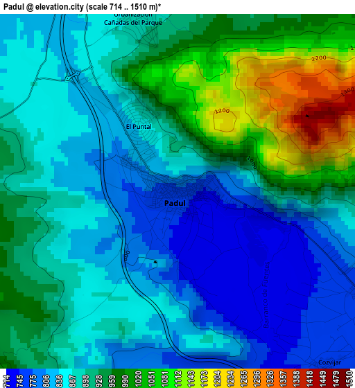
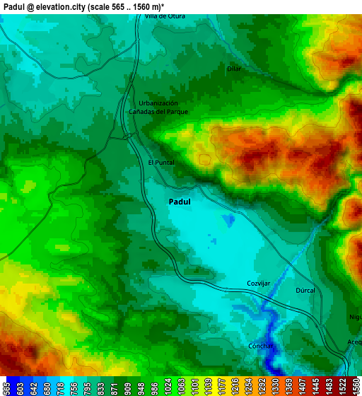
Below is the Elevation map of Padul, which displays elevation range with different colors. Scale of the first map is from 714 to 1510 m (2343 to 4954 ft) with average elevation of 900.4 meters (=2954 ft) [note 1]
These maps also provides idea of topography and contour of this city, they are displayed at different zoom levels. More info about maps, scale and edge coordinates you can find below images.
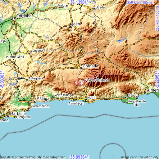
| \ | Map #1 | Map #2 | Topo.Map |
| Scale [m] | 714..1510 m | 565..1560 m | × |
| Scale [ft] | 2343..4954 ft | 1854..5118 ft | × |
| Average | 900.4 m = 2954 ft | 941.6 m = 3089 ft | × |
| Width | 7.8 km = 4.8 mi | 15.6 km = 9.7 mi | 249.7 km = 155.2 mi |
| Height | 7.8 km = 4.8 mi | 15.6 km = 9.7 mi | 249.7 km = 155.2 mi |
| ↑Max Latitude | 37.059697° | 37.094757° | 38.13901° |
| Latitude at center | 37.02462° | 37.02462° | 37.02462° |
| ↓Min Latitude | 36.989527° | 36.954418° | 35.89364° |
| ← Min Longitude | -3.670725° | -3.714671° | -5.03303° |
| Longitude center | -3.62678° | -3.62678° | -3.62678° |
| →Max Longitude | -3.582835° | -3.538889° | -2.22053° |
Nearby cities:
Cities around Padul sort by population:
• Zubia elevation 755 m
11.2 km,  19°
19°
• Las Gabias 686 m
12.9 km,  342°
342°
• Ogíjares 723 m
10.6 km,  9°
9°
• Dúrcal 789 m
6.8 km,  127°
127°
• Otura 803 m
7.1 km,  355°
355°
• Gójar 794 m
9.1 km, 11°
• Alhendín 736 m
9.5 km,  349°
349°
• Cájar 725 m
13.1 km, 21°
• Dílar 892 m
5.8 km, 22°
• Albuñuelas 730 m
10.7 km,  182°
182°
• Nigüelas 930 m
9.3 km,  123°
123°
• Escúzar 874 m
12.6 km,  289°
289°
Multilingual:
 En español:
Padul elevación 766 m.
 En France:
Padul élévation 766 m.


Sources and notes:
- [note 1] Map square and city borders are not equal. Map elevation data is calculated only from area inside that square.
- [src 1] Elevation data from geonames database provided with same terms of usage.
- [src 2] The elevation map of Padul is generated using elevation data from NASA's 3 arcsec (90m) resolution SRTM data.
- [src 3] Base (background) map © OpenStreetMap contributors tiles are generated by Geofabrik and OpenTopoMap.
Copyright & License:
This Padul Elevation Map is licensed under CC BY-SA. You may reuse any part from this page, if you give a proper credit by linking to this URL:
 More info on terms of use page.