Ítrabo elevation
Ítrabo (Andalusia, Provincia de Granada), Spain elevation is 396 meters and Ítrabo elevation in feet is 1299 ft above sea level [src 1]. Ítrabo is a populated place (feature code) with elevation that is 207 meters (679 ft) smaller than average city elevation in Spain.
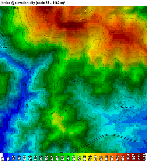
Below is the Elevation map of Ítrabo, which displays elevation range with different colors. Scale of the first map is from 55 to 1162 m (180 to 3812 ft) with average elevation of 498.7 meters (=1636 ft) [note 1]
These maps also provides idea of topography and contour of this city, they are displayed at different zoom levels. More info about maps, scale and edge coordinates you can find below images.
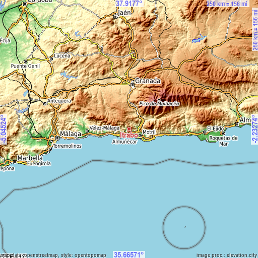
| \ | Map #1 | Topo.Map |
| Scale [m] | 55..1162 m | × |
| Scale [ft] | 180..3812 ft | × |
| Average | 498.7 m = 1636 ft | × |
| Width | 7.83 km = 4.9 mi | 250.4 km = 155.6 mi |
| Height | 7.83 km = 4.9 mi | 250.4 km = 155.6 mi |
| ↑Max Latitude | 36.83516° | 37.9177° |
| Latitude at center | 36.79998° | 36.79998° |
| ↓Min Latitude | 36.764784° | 35.66571° |
| ← Min Longitude | -3.682935° | -5.04524° |
| Longitude center | -3.63899° | -3.63899° |
| →Max Longitude | -3.595045° | -2.23274° |
Nearby cities:
Cities around Ítrabo sort by population:
• Motril elevation 65 m
12.1 km,  116°
116°
• Almuñécar 24 m
8.7 km,  212°
212°
• Salobreña 45 m
7.9 km,  144°
144°
• La Herradura 39 m
11.4 km,  230°
230°
• Molvízar 233 m
3.2 km, 119°
• Vélez de Benaudalla 181 m
11.6 km,  71°
71°
• Torrenueva 6 m
17.1 km,  128°
128°
• El Varadero 4 m
13.3 km, 128°
• Albuñuelas 730 m
14.3 km,  2°
2°
• Otívar 316 m
4 km,  295°
295°
• Lentegí 649 m
5.1 km,  322°
322°
• Jete 147 m
2.5 km,  262°
262°
Multilingual:
 En español:
Ítrabo elevación 396 m.
 En France:
Ítrabo élévation 396 m.


Sources and notes:
- [note 1] Map square and city borders are not equal. Map elevation data is calculated only from area inside that square.
- [src 1] Elevation data from geonames database provided with same terms of usage.
- [src 2] The elevation map of Ítrabo is generated using elevation data from NASA's 3 arcsec (90m) resolution SRTM data.
- [src 3] Base (background) map © OpenStreetMap contributors tiles are generated by Geofabrik and OpenTopoMap.
Copyright & License:
This Ítrabo Elevation Map is licensed under CC BY-SA. You may reuse any part from this page, if you give a proper credit by linking to this URL:
 More info on terms of use page.