Motril elevation
Motril (Andalusia, Provincia de Granada), Spain elevation is 65 meters and Motril elevation in feet is 213 ft above sea level [src 1]. Motril is a seat of a third-order administrative division (feature code) with elevation that is 538 meters (1765 ft) smaller than average city elevation in Spain.
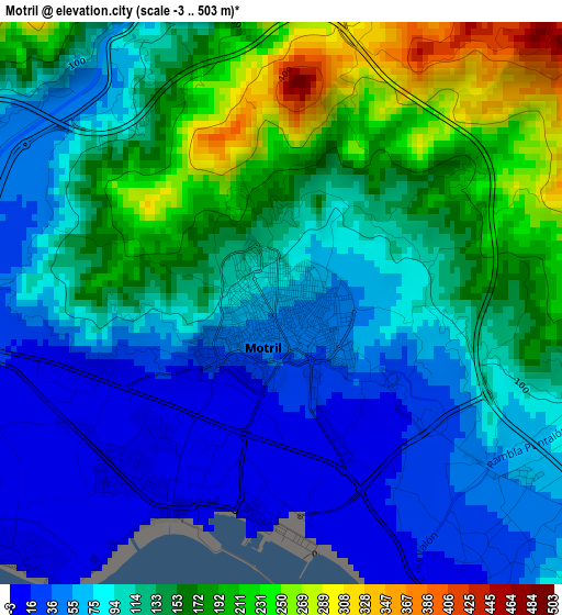
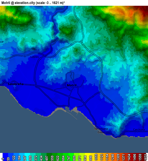
Below is the Elevation map of Motril, which displays elevation range with different colors. Scale of the first map is from -3 to 503 m (-10 to 1650 ft) with average elevation of 116.7 meters (=383 ft) [note 1]
These maps also provides idea of topography and contour of this city, they are displayed at different zoom levels. More info about maps, scale and edge coordinates you can find below images.
| \ | Map #1 | Map #2 | Topo.Map |
| Scale [m] | -3..503 m | -3..1621 m | × |
| Scale [ft] | -10..1650 ft | -10..5318 ft | × |
| Average | 116.7 m = 383 ft | 266.5 m = 874 ft | × |
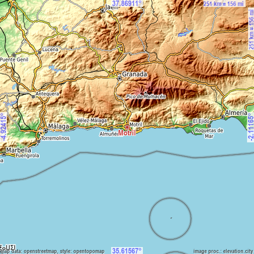
| Width | 7.83 km = 4.9 mi | 15.66 km = 9.7 mi | 250.6 km = 155.7 mi |
| Height | 7.83 km = 4.9 mi | 15.66 km = 9.7 mi | 250.6 km = 155.7 mi |
| ↑Max Latitude | 36.785863° | 36.82105° | 37.86911° |
| Latitude at center | 36.75066° | 36.75066° | 36.75066° |
| ↓Min Latitude | 36.715441° | 36.680206° | 35.61567° |
| ← Min Longitude | -3.561845° | -3.605791° | -4.92415° |
| Longitude center | -3.5179° | -3.5179° | -3.5179° |
| →Max Longitude | -3.473955° | -3.430009° | -2.11165° |
Nearby cities:
Cities around Motril sort by population:
• Almuñécar elevation 24 m
15.5 km,  263°
263°
• Salobreña 45 m
6.2 km, 261°
• Castell de Ferro 21 m
14.8 km,  100°
100°
• Molvízar 233 m
8.9 km,  296°
296°
• Vélez de Benaudalla 181 m
9.1 km,  1°
1°
• Gualchos 355 m
11.3 km,  93°
93°
• Torrenueva 6 m
5.8 km,  154°
154°
• El Varadero 4 m
2.9 km,  187°
187°
• Ítrabo 396 m
12.1 km, 296°
• Otívar 316 m
16.1 km, 296°
• Lújar 564 m
11 km,  67°
67°
• Jete 147 m
14.3 km,  291°
291°
Multilingual:
 En español:
Motril elevación 65 m.
 En France:
Motril élévation 65 m.


Sources and notes:
- [note 1] Map square and city borders are not equal. Map elevation data is calculated only from area inside that square.
- [src 1] Elevation data from geonames database provided with same terms of usage.
- [src 2] The elevation map of Motril is generated using elevation data from NASA's 3 arcsec (90m) resolution SRTM data.
- [src 3] Base (background) map © OpenStreetMap contributors tiles are generated by Geofabrik and OpenTopoMap.
Copyright & License:
This Motril Elevation Map is licensed under CC BY-SA. You may reuse any part from this page, if you give a proper credit by linking to this URL:
 More info on terms of use page.