Jayena elevation
Jayena (Andalusia, Provincia de Granada), Spain elevation is 914 meters and Jayena elevation in feet is 2999 ft above sea level [src 1]. Jayena is a seat of a third-order administrative division (feature code) with elevation that is 311 meters (1020 ft) bigger than average city elevation in Spain.
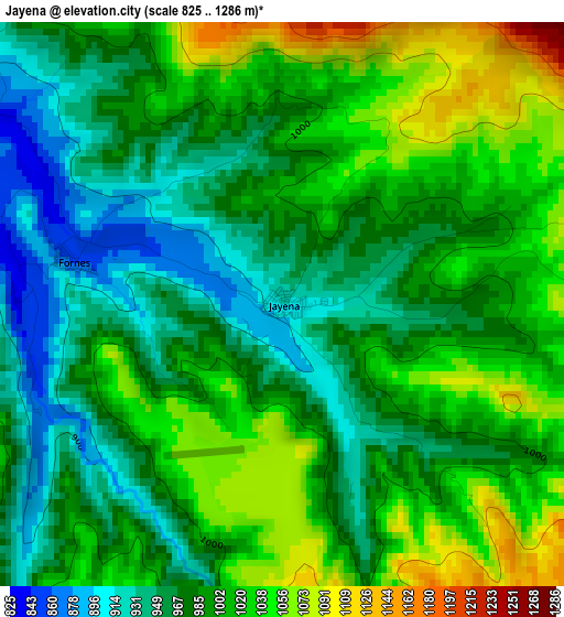
Below is the Elevation map of Jayena, which displays elevation range with different colors. Scale of the first map is from 825 to 1286 m (2707 to 4219 ft) with average elevation of 993.4 meters (=3259 ft) [note 1]
These maps also provides idea of topography and contour of this city, they are displayed at different zoom levels. More info about maps, scale and edge coordinates you can find below images.
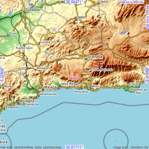
| \ | Map #1 | Topo.Map |
| Scale [m] | 825..1286 m | × |
| Scale [ft] | 2707..4219 ft | × |
| Average | 993.4 m = 3259 ft | × |
| Width | 7.81 km = 4.9 mi | 249.9 km = 155.3 mi |
| Height | 7.81 km = 4.9 mi | 249.9 km = 155.3 mi |
| ↑Max Latitude | 36.984312° | 38.06471° |
| Latitude at center | 36.9492° | 36.9492° |
| ↓Min Latitude | 36.914072° | 35.81711° |
| ← Min Longitude | -3.867075° | -5.22938° |
| Longitude center | -3.82313° | -3.82313° |
| →Max Longitude | -3.779185° | -2.41688° |
Nearby cities:
Cities around Jayena sort by population:
• Padul elevation 766 m
19.4 km,  64°
64°
• Alhama de Granada 879 m
16.1 km,  293°
293°
• Cómpeta 648 m
18.6 km,  226°
226°
• Frigiliana 312 m
19.1 km,  199°
199°
• Arenas del Rey 867 m
6.3 km,  278°
278°
• Albuñuelas 730 m
17.2 km,  97°
97°
• Canillas de Albaida 608 m
18.5 km, 231°
• Escúzar 874 m
13.7 km,  23°
23°
• Ventas de Huelma 858 m
13.3 km,  1°
1°
• Árchez 436 m
19.3 km, 231°
• Lentegí 649 m
18.3 km,  133°
133°
• Agrón 1051 m
9 km,  356°
356°
Multilingual:
 En español:
Jayena elevación 914 m.
 En France:
Jayena élévation 914 m.


Sources and notes:
- [note 1] Map square and city borders are not equal. Map elevation data is calculated only from area inside that square.
- [src 1] Elevation data from geonames database provided with same terms of usage.
- [src 2] The elevation map of Jayena is generated using elevation data from NASA's 3 arcsec (90m) resolution SRTM data.
- [src 3] Base (background) map © OpenStreetMap contributors tiles are generated by Geofabrik and OpenTopoMap.
Copyright & License:
This Jayena Elevation Map is licensed under CC BY-SA. You may reuse any part from this page, if you give a proper credit by linking to this URL:
 More info on terms of use page.