Cómpeta elevation
Cómpeta (Andalusia, Provincia de Málaga), Spain elevation is 648 meters and Cómpeta elevation in feet is 2126 ft above sea level [src 1]. Cómpeta is a seat of a third-order administrative division (feature code) with elevation that is 45 meters (148 ft) bigger than average city elevation in Spain.
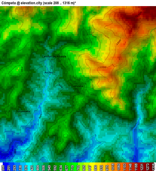
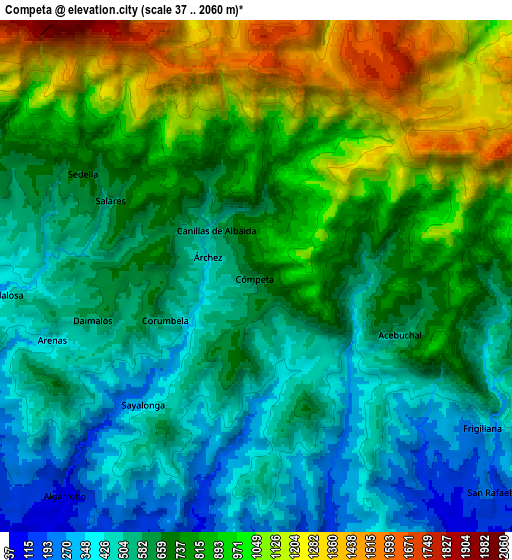
Below is the Elevation map of Cómpeta, which displays elevation range with different colors. Scale of the first map is from 208 to 1316 m (682 to 4318 ft) with average elevation of 642.3 meters (=2107 ft) [note 1]
These maps also provides idea of topography and contour of this city, they are displayed at different zoom levels. More info about maps, scale and edge coordinates you can find below images.
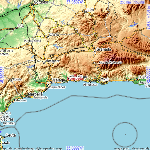
| \ | Map #1 | Map #2 | Topo.Map |
| Scale [m] | 208..1316 m | 37..2060 m | × |
| Scale [ft] | 682..4318 ft | 121..6759 ft | × |
| Average | 642.3 m = 2107 ft | 731.5 m = 2400 ft | × |
| Width | 7.82 km = 4.9 mi | 15.64 km = 9.7 mi | 250.3 km = 155.5 mi |
| Height | 7.82 km = 4.9 mi | 15.64 km = 9.7 mi | 250.3 km = 155.5 mi |
| ↑Max Latitude | 36.868685° | 36.903834° | 37.95074° |
| Latitude at center | 36.83352° | 36.83352° | 36.83352° |
| ↓Min Latitude | 36.798339° | 36.763142° | 35.69974° |
| ← Min Longitude | -4.018245° | -4.062191° | -5.38055° |
| Longitude center | -3.9743° | -3.9743° | -3.9743° |
| →Max Longitude | -3.930355° | -3.886409° | -2.56805° |
Nearby cities:
Cities around Cómpeta sort by population:
• Vélez-Málaga elevation 62 m
12.8 km,  242°
242°
• Nerja 51 m
12.6 km,  135°
135°
• Torrox 147 m
8.6 km,  166°
166°
• Algarrobo 90 m
8.8 km,  221°
221°
• Frigiliana 312 m
8.8 km,  125°
125°
• Canillas de Aceituno 648 m
10.6 km,  294°
294°
• Sayalonga 347 m
5.2 km, 221°
• Arenas 415 m
6.5 km,  252°
252°
• Canillas de Albaida 608 m
1.8 km,  322°
322°
• Árchez 436 m
1.7 km, 294°
• Salares 586 m
5 km,  297°
297°
• Sedella 689 m
6.1 km, 301°
Multilingual:
 En español:
Cómpeta elevación 648 m.
 En France:
Cómpeta élévation 648 m.


Sources and notes:
- [note 1] Map square and city borders are not equal. Map elevation data is calculated only from area inside that square.
- [src 1] Elevation data from geonames database provided with same terms of usage.
- [src 2] The elevation map of Cómpeta is generated using elevation data from NASA's 3 arcsec (90m) resolution SRTM data.
- [src 3] Base (background) map © OpenStreetMap contributors tiles are generated by Geofabrik and OpenTopoMap.
Copyright & License:
This Cómpeta Elevation Map is licensed under CC BY-SA. You may reuse any part from this page, if you give a proper credit by linking to this URL:
 More info on terms of use page.