Aliseda elevation
Aliseda (Extremadura, Provincia de Cáceres), Spain elevation is 333 meters and Aliseda elevation in feet is 1093 ft above sea level [src 1]. Aliseda is a seat of a third-order administrative division (feature code) with elevation that is 270 meters (886 ft) smaller than average city elevation in Spain.
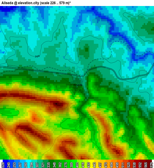
Below is the Elevation map of Aliseda, which displays elevation range with different colors. Scale of the first map is from 226 to 579 m (741 to 1900 ft) with average elevation of 358 meters (=1175 ft) [note 1]
These maps also provides idea of topography and contour of this city, they are displayed at different zoom levels. More info about maps, scale and edge coordinates you can find below images.
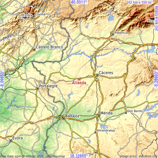
| \ | Map #1 | Topo.Map |
| Scale [m] | 226..579 m | × |
| Scale [ft] | 741..1900 ft | × |
| Average | 358 m = 1175 ft | × |
| Width | 7.55 km = 4.7 mi | 241.6 km = 150.1 mi |
| Height | 7.55 km = 4.7 mi | 241.6 km = 150.1 mi |
| ↑Max Latitude | 39.457228° | 40.5011° |
| Latitude at center | 39.42329° | 39.42329° |
| ↓Min Latitude | 39.389335° | 38.32855° |
| ← Min Longitude | -6.736225° | -8.09853° |
| Longitude center | -6.69228° | -6.69228° |
| →Max Longitude | -6.648335° | -5.28603° |
Nearby cities:
Cities around Aliseda sort by population:
• Cáceres elevation 441 m
28.1 km,  77°
77°
• Arroyo de la Luz 352 m
11.6 km,  53°
53°
• Casar de Cáceres 369 m
28 km,  56°
56°
• Malpartida de Cáceres 371 m
16.1 km, 80°
• Garrovillas 328 m
34.2 km,  20°
20°
• Brozas 409 m
22.3 km,  340°
340°
• Puebla de Obando 376 m
28 km,  168°
168°
• La Roca de la Sierra 248 m
34.9 km,  179°
179°
• Navas del Madroño 438 m
22.5 km,  8°
8°
• Salorino 323 m
27.8 km,  283°
283°
• Mata de Alcántara 336 m
34.4 km, 341°
• Villa del Rey 340 m
28.5 km, 337°
Multilingual:
 En español:
Aliseda elevación 333 m.
 En France:
Aliseda élévation 333 m.


Sources and notes:
- [note 1] Map square and city borders are not equal. Map elevation data is calculated only from area inside that square.
- [src 1] Elevation data from geonames database provided with same terms of usage.
- [src 2] The elevation map of Aliseda is generated using elevation data from NASA's 3 arcsec (90m) resolution SRTM data.
- [src 3] Base (background) map © OpenStreetMap contributors tiles are generated by Geofabrik and OpenTopoMap.
Copyright & License:
This Aliseda Elevation Map is licensed under CC BY-SA. You may reuse any part from this page, if you give a proper credit by linking to this URL:
 More info on terms of use page.