Brozas elevation
Brozas (Extremadura, Provincia de Cáceres), Spain elevation is 409 meters and Brozas elevation in feet is 1342 ft above sea level [src 1]. Brozas is a populated place (feature code) with elevation that is 194 meters (636 ft) smaller than average city elevation in Spain.
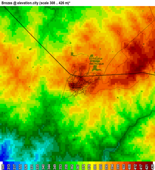
Below is the Elevation map of Brozas, which displays elevation range with different colors. Scale of the first map is from 308 to 426 m (1010 to 1398 ft) with average elevation of 374.8 meters (=1230 ft) [note 1]
These maps also provides idea of topography and contour of this city, they are displayed at different zoom levels. More info about maps, scale and edge coordinates you can find below images.
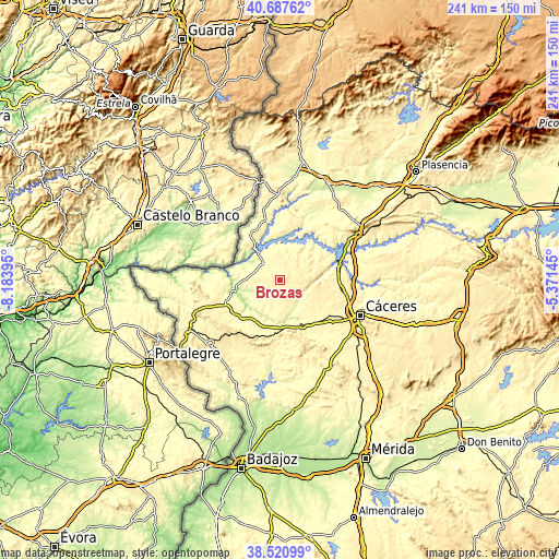
| \ | Map #1 | Topo.Map |
| Scale [m] | 308..426 m | × |
| Scale [ft] | 1010..1398 ft | × |
| Average | 374.8 m = 1230 ft | × |
| Width | 7.53 km = 4.7 mi | 240.9 km = 149.7 mi |
| Height | 7.53 km = 4.7 mi | 240.9 km = 149.7 mi |
| ↑Max Latitude | 39.646626° | 40.68762° |
| Latitude at center | 39.61278° | 39.61278° |
| ↓Min Latitude | 39.578918° | 38.52099° |
| ← Min Longitude | -6.821645° | -8.18395° |
| Longitude center | -6.7777° | -6.7777° |
| →Max Longitude | -6.733755° | -5.37145° |
Nearby cities:
Cities around Brozas sort by population:
• Arroyo de la Luz elevation 352 m
21.8 km,  130°
130°
• Malpartida de Cáceres 371 m
29.6 km, 128°
• Garrovillas 328 m
22.3 km,  60°
60°
• Ceclavín 332 m
23.3 km,  0°
0°
• Aliseda 333 m
22.3 km,  160°
160°
• Alcántara 240 m
14.9 km,  322°
322°
• Navas del Madroño 438 m
10.8 km,  84°
84°
• Zarza la Mayor 305 m
30.2 km,  346°
346°
• Salorino 323 m
24.6 km,  233°
233°
• Mata de Alcántara 336 m
12.1 km,  343°
343°
• Piedras Albas 352 m
22.9 km,  326°
326°
• Villa del Rey 340 m
6.4 km, 324°
Multilingual:
 En español:
Brozas elevación 409 m.
 En France:
Brozas élévation 409 m.


Sources and notes:
- [note 1] Map square and city borders are not equal. Map elevation data is calculated only from area inside that square.
- [src 1] Elevation data from geonames database provided with same terms of usage.
- [src 2] The elevation map of Brozas is generated using elevation data from NASA's 3 arcsec (90m) resolution SRTM data.
- [src 3] Base (background) map © OpenStreetMap contributors tiles are generated by Geofabrik and OpenTopoMap.
Copyright & License:
This Brozas Elevation Map is licensed under CC BY-SA. You may reuse any part from this page, if you give a proper credit by linking to this URL:
 More info on terms of use page.