Casar de Cáceres elevation
Casar de Cáceres (Extremadura, Provincia de Cáceres), Spain elevation is 369 meters and Casar de Cáceres elevation in feet is 1211 ft above sea level [src 1]. Casar de Cáceres is a populated place (feature code) with elevation that is 234 meters (768 ft) smaller than average city elevation in Spain.
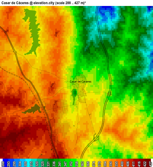
Below is the Elevation map of Casar de Cáceres, which displays elevation range with different colors. Scale of the first map is from 288 to 427 m (945 to 1401 ft) with average elevation of 370.9 meters (=1217 ft) [note 1]
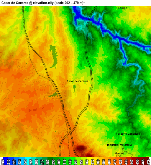
These maps also provides idea of topography and contour of this city, they are displayed at different zoom levels. More info about maps, scale and edge coordinates you can find below images.
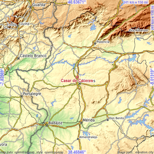
| \ | Map #1 | Map #2 | Topo.Map |
| Scale [m] | 288..427 m | 202..479 m | × |
| Scale [ft] | 945..1401 ft | 663..1572 ft | × |
| Average | 370.9 m = 1217 ft | 358.6 m = 1177 ft | × |
| Width | 7.53 km = 4.7 mi | 15.07 km = 9.4 mi | 241.1 km = 149.8 mi |
| Height | 7.53 km = 4.7 mi | 15.07 km = 9.4 mi | 241.1 km = 149.8 mi |
| ↑Max Latitude | 39.594931° | 39.628786° | 40.63671° |
| Latitude at center | 39.56106° | 39.56106° | 39.56106° |
| ↓Min Latitude | 39.527172° | 39.493268° | 38.46846° |
| ← Min Longitude | -6.463385° | -6.507331° | -7.82569° |
| Longitude center | -6.41944° | -6.41944° | -6.41944° |
| →Max Longitude | -6.375495° | -6.331549° | -5.01319° |
Nearby cities:
Cities around Casar de Cáceres sort by population:
• Cáceres elevation 441 m
10.2 km,  156°
156°
• Arroyo de la Luz 352 m
16.4 km,  239°
239°
• Malpartida de Cáceres 371 m
14.8 km,  210°
210°
• Garrovillas 328 m
20.1 km,  326°
326°
• Sierra de Fuentes 421 m
18.4 km,  136°
136°
• Torreorgaz 427 m
24.6 km, 143°
• Navas del Madroño 438 m
21.1 km,  288°
288°
• Cañaveral 368 m
25.8 km,  5°
5°
• Talaván 375 m
21 km,  34°
34°
• Torrequemada 440 m
27.5 km, 141°
• Hinojal 337 m
17.3 km,  18°
18°
• Santiago del Campo 344 m
8.9 km, 32°
Multilingual:
 En español:
Casar de Cáceres elevación 369 m.
 En France:
Casar de Cáceres élévation 369 m.
 Auf Deutsch:
Casar de Cáceres höhe über dem Meeresspiegel ist 369 m.

Sources and notes:
- [note 1] Map square and city borders are not equal. Map elevation data is calculated only from area inside that square.
- [src 1] Elevation data from geonames database provided with same terms of usage.
- [src 2] The elevation map of Casar de Cáceres is generated using elevation data from NASA's 3 arcsec (90m) resolution SRTM data.
- [src 3] Base (background) map © OpenStreetMap contributors tiles are generated by Geofabrik and OpenTopoMap.
Copyright & License:
This Casar de Cáceres Elevation Map is licensed under CC BY-SA. You may reuse any part from this page, if you give a proper credit by linking to this URL:
 More info on terms of use page.