Talaván elevation
Talaván (Extremadura, Provincia de Cáceres), Spain elevation is 375 meters and Talaván elevation in feet is 1230 ft above sea level [src 1]. Talaván is a seat of a third-order administrative division (feature code) with elevation that is 228 meters (748 ft) smaller than average city elevation in Spain.
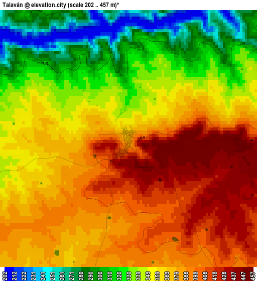
Below is the Elevation map of Talaván, which displays elevation range with different colors. Scale of the first map is from 202 to 457 m (663 to 1499 ft) with average elevation of 359.9 meters (=1181 ft) [note 1]
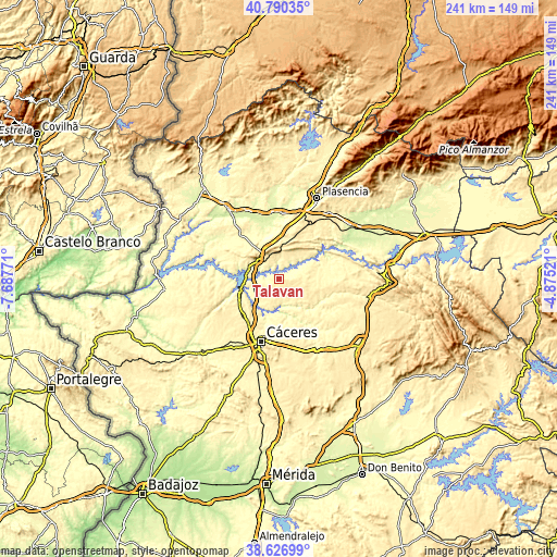
These maps also provides idea of topography and contour of this city, they are displayed at different zoom levels. More info about maps, scale and edge coordinates you can find below images.
| \ | Map #1 | Topo.Map |
| Scale [m] | 202..457 m | × |
| Scale [ft] | 663..1499 ft | × |
| Average | 359.9 m = 1181 ft | × |
| Width | 7.52 km = 4.7 mi | 240.5 km = 149.4 mi |
| Height | 7.52 km = 4.7 mi | 240.5 km = 149.4 mi |
| ↑Max Latitude | 39.750945° | 40.79035° |
| Latitude at center | 39.71715° | 39.71715° |
| ↓Min Latitude | 39.683339° | 38.62699° |
| ← Min Longitude | -6.325405° | -7.68771° |
| Longitude center | -6.28146° | -6.28146° |
| →Max Longitude | -6.237515° | -4.87521° |
Nearby cities:
Cities around Talaván sort by population:
• Casar de Cáceres elevation 369 m
21 km,  214°
214°
• Garrovillas 328 m
23 km,  268°
268°
• Serradilla 413 m
17.3 km,  44°
44°
• Ríolobos 269 m
22.7 km,  355°
355°
• Cañaveral 368 m
12.5 km,  311°
311°
• Holguera 278 m
21.1 km,  343°
343°
• Mirabel 500 m
16.7 km,  14°
14°
• Casas de Millán 471 m
11.9 km, 339°
• Hinojal 337 m
6.4 km,  261°
261°
• Santiago del Campo 344 m
12.1 km,  215°
215°
• Portezuelo 374 m
19.6 km,  302°
302°
• Pedroso de Acim 464 m
16.4 km,  317°
317°
Multilingual:
 En español:
Talaván elevación 375 m.
 En France:
Talaván élévation 375 m.


Sources and notes:
- [note 1] Map square and city borders are not equal. Map elevation data is calculated only from area inside that square.
- [src 1] Elevation data from geonames database provided with same terms of usage.
- [src 2] The elevation map of Talaván is generated using elevation data from NASA's 3 arcsec (90m) resolution SRTM data.
- [src 3] Base (background) map © OpenStreetMap contributors tiles are generated by Geofabrik and OpenTopoMap.
Copyright & License:
This Talaván Elevation Map is licensed under CC BY-SA. You may reuse any part from this page, if you give a proper credit by linking to this URL:
 More info on terms of use page.