Serradilla elevation
Serradilla (Extremadura, Provincia de Cáceres), Spain elevation is 413 meters and Serradilla elevation in feet is 1355 ft above sea level [src 1]. Serradilla is a seat of a third-order administrative division (feature code) with elevation that is 190 meters (623 ft) smaller than average city elevation in Spain.
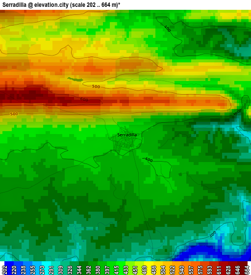
Below is the Elevation map of Serradilla, which displays elevation range with different colors. Scale of the first map is from 202 to 664 m (663 to 2178 ft) with average elevation of 411.6 meters (=1350 ft) [note 1]
These maps also provides idea of topography and contour of this city, they are displayed at different zoom levels. More info about maps, scale and edge coordinates you can find below images.
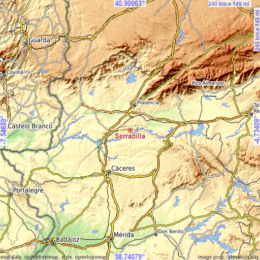
| \ | Map #1 | Topo.Map |
| Scale [m] | 202..664 m | × |
| Scale [ft] | 663..2178 ft | × |
| Average | 411.6 m = 1350 ft | × |
| Width | 7.5 km = 4.7 mi | 240.2 km = 149.3 mi |
| Height | 7.5 km = 4.7 mi | 240.1 km = 149.2 mi |
| ↑Max Latitude | 39.86294° | 40.90063° |
| Latitude at center | 39.8292° | 39.8292° |
| ↓Min Latitude | 39.795444° | 38.74079° |
| ← Min Longitude | -6.184285° | -7.54659° |
| Longitude center | -6.14034° | -6.14034° |
| →Max Longitude | -6.096395° | -4.73409° |
Nearby cities:
Cities around Serradilla sort by population:
• Plasencia elevation 368 m
22.9 km,  11°
11°
• Malpartida de Plasencia 457 m
18.6 km,  25°
25°
• Galisteo 305 m
19.7 km,  326°
326°
• Ríolobos 269 m
17.3 km,  306°
306°
• Cañaveral 368 m
21.8 km,  259°
259°
• Talaván 375 m
17.3 km,  224°
224°
• Holguera 278 m
19.5 km,  293°
293°
• Mirabel 500 m
8.7 km,  295°
295°
• Casas de Millán 471 m
16.2 km,  265°
265°
• Torrejón el Rubio 306 m
12.7 km,  120°
120°
• Hinojal 337 m
22.7 km,  234°
234°
• Pedroso de Acim 464 m
23.2 km, 268°
Multilingual:
 En español:
Serradilla elevación 413 m.
 En France:
Serradilla élévation 413 m.
 Auf Deutsch:
Serradilla höhe über dem Meeresspiegel ist 413 m.

Sources and notes:
- [note 1] Map square and city borders are not equal. Map elevation data is calculated only from area inside that square.
- [src 1] Elevation data from geonames database provided with same terms of usage.
- [src 2] The elevation map of Serradilla is generated using elevation data from NASA's 3 arcsec (90m) resolution SRTM data.
- [src 3] Base (background) map © OpenStreetMap contributors tiles are generated by Geofabrik and OpenTopoMap.
Copyright & License:
This Serradilla Elevation Map is licensed under CC BY-SA. You may reuse any part from this page, if you give a proper credit by linking to this URL:
 More info on terms of use page.