Cañamero elevation
Cañamero (Extremadura, Provincia de Cáceres), Spain elevation is 609 meters and Cañamero elevation in feet is 1998 ft above sea level [src 1]. Cañamero is a seat of a third-order administrative division (feature code) with elevation that is 6 meters (20 ft) bigger than average city elevation in Spain.
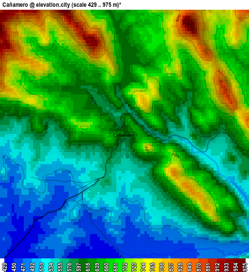
Below is the Elevation map of Cañamero, which displays elevation range with different colors. Scale of the first map is from 429 to 975 m (1407 to 3199 ft) with average elevation of 617.9 meters (=2027 ft) [note 1]
These maps also provides idea of topography and contour of this city, they are displayed at different zoom levels. More info about maps, scale and edge coordinates you can find below images.
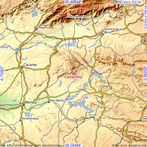
| \ | Map #1 | Topo.Map |
| Scale [m] | 429..975 m | × |
| Scale [ft] | 1407..3199 ft | × |
| Average | 617.9 m = 2027 ft | × |
| Width | 7.55 km = 4.7 mi | 241.7 km = 150.2 mi |
| Height | 7.55 km = 4.7 mi | 241.7 km = 150.2 mi |
| ↑Max Latitude | 39.41391° | 40.45844° |
| Latitude at center | 39.37995° | 39.37995° |
| ↓Min Latitude | 39.345974° | 38.28454° |
| ← Min Longitude | -5.432515° | -6.79482° |
| Longitude center | -5.38857° | -5.38857° |
| →Max Longitude | -5.344625° | -3.98232° |
Nearby cities:
Cities around Cañamero sort by population:
• Guadalupe elevation 640 m
9.5 km,  34°
34°
• Logrosán 473 m
10.2 km,  241°
241°
• Valdecaballeros 406 m
22.9 km,  131°
131°
• Castañar de Ibor 650 m
27.7 km,  354°
354°
• Alía 576 m
16.5 km,  62°
62°
• Castilblanco 505 m
27.7 km,  112°
112°
• Aldeacentenera 566 m
26.4 km,  308°
308°
• Navezuelas 933 m
15 km,  343°
343°
• Cabañas del Castillo 771 m
21.5 km,  330°
330°
• Navalvillar de Ibor 677 m
22.8 km, 354°
• Robledollano 713 m
27.5 km, 338°
• Puerto de San Vicente 750 m
28.4 km, 56°
Multilingual:
 En español:
Cañamero elevación 609 m.
 En France:
Cañamero élévation 609 m.
 Auf Deutsch:
Cañamero höhe über dem Meeresspiegel ist 609 m.

Sources and notes:
- [note 1] Map square and city borders are not equal. Map elevation data is calculated only from area inside that square.
- [src 1] Elevation data from geonames database provided with same terms of usage.
- [src 2] The elevation map of Cañamero is generated using elevation data from NASA's 3 arcsec (90m) resolution SRTM data.
- [src 3] Base (background) map © OpenStreetMap contributors tiles are generated by Geofabrik and OpenTopoMap.
Copyright & License:
This Cañamero Elevation Map is licensed under CC BY-SA. You may reuse any part from this page, if you give a proper credit by linking to this URL:
 More info on terms of use page.