Puerto de San Vicente elevation
Puerto de San Vicente (Castille-La Mancha, Province of Toledo), Spain elevation is 750 meters and Puerto de San Vicente elevation in feet is 2461 ft above sea level [src 1]. Puerto de San Vicente is a seat of a third-order administrative division (feature code) with elevation that is 147 meters (482 ft) bigger than average city elevation in Spain.
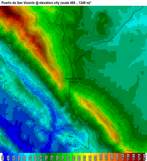
Below is the Elevation map of Puerto de San Vicente, which displays elevation range with different colors. Scale of the first map is from 469 to 1248 m (1539 to 4094 ft) with average elevation of 714.2 meters (=2343 ft) [note 1]
These maps also provides idea of topography and contour of this city, they are displayed at different zoom levels. More info about maps, scale and edge coordinates you can find below images.
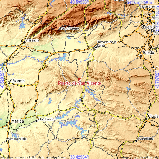
| \ | Map #1 | Topo.Map |
| Scale [m] | 469..1248 m | × |
| Scale [ft] | 1539..4094 ft | × |
| Average | 714.2 m = 2343 ft | × |
| Width | 7.54 km = 4.7 mi | 241.2 km = 149.9 mi |
| Height | 7.54 km = 4.7 mi | 241.2 km = 149.9 mi |
| ↑Max Latitude | 39.55672° | 40.59908° |
| Latitude at center | 39.52283° | 39.52283° |
| ↓Min Latitude | 39.488924° | 38.42964° |
| ← Min Longitude | -5.158015° | -6.52032° |
| Longitude center | -5.11407° | -5.11407° |
| →Max Longitude | -5.070125° | -3.70782° |
Nearby cities:
Cities around Puerto de San Vicente sort by population:
• Guadalupe elevation 640 m
19.9 km,  246°
246°
• Rosalejo 495 m
20.1 km,  118°
118°
• Alía 576 m
12.2 km,  226°
226°
• Castilblanco 505 m
26.5 km,  175°
175°
• Sevilleja de la Jara 664 m
14.1 km,  65°
65°
• Villar del Pedroso 495 m
21.6 km,  341°
341°
• Mohedas de la Jara 644 m
9.4 km, 344°
• Aldeanueva de San Bartolomé 580 m
12.6 km,  0°
0°
• Navalvillar de Ibor 677 m
26.5 km,  284°
284°
• Navalmoralejo 428 m
24.2 km,  354°
354°
• Anchuras 548 m
24.5 km,  101°
101°
• Carrascalejo 633 m
15.1 km,  324°
324°
Multilingual:
 En español:
Puerto de San Vicente elevación 750 m.
 En France:
Puerto de San Vicente élévation 750 m.
 Auf Deutsch:
Puerto de San Vicente höhe über dem Meeresspiegel ist 750 m.
 На русском:
Puerto de San Vicente высота над уровнем моря 750 м
Sources and notes:
- [note 1] Map square and city borders are not equal. Map elevation data is calculated only from area inside that square.
- [src 1] Elevation data from geonames database provided with same terms of usage.
- [src 2] The elevation map of Puerto de San Vicente is generated using elevation data from NASA's 3 arcsec (90m) resolution SRTM data.
- [src 3] Base (background) map © OpenStreetMap contributors tiles are generated by Geofabrik and OpenTopoMap.
Copyright & License:
This Puerto de San Vicente Elevation Map is licensed under CC BY-SA. You may reuse any part from this page, if you give a proper credit by linking to this URL:
 More info on terms of use page.