Anchuras elevation
Anchuras (Castille-La Mancha, Provincia de Ciudad Real), Spain elevation is 548 meters and Anchuras elevation in feet is 1798 ft above sea level [src 1]. Anchuras is a seat of a third-order administrative division (feature code) with elevation that is 55 meters (180 ft) smaller than average city elevation in Spain.
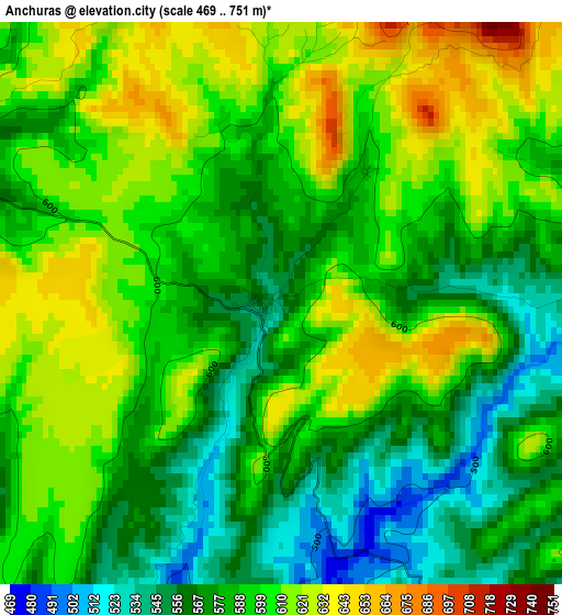
Below is the Elevation map of Anchuras, which displays elevation range with different colors. Scale of the first map is from 469 to 751 m (1539 to 2464 ft) with average elevation of 591.5 meters (=1941 ft) [note 1]
These maps also provides idea of topography and contour of this city, they are displayed at different zoom levels. More info about maps, scale and edge coordinates you can find below images.
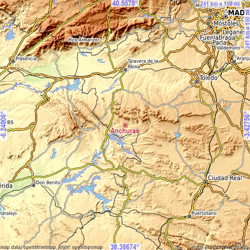
| \ | Map #1 | Topo.Map |
| Scale [m] | 469..751 m | × |
| Scale [ft] | 1539..2464 ft | × |
| Average | 591.5 m = 1941 ft | × |
| Width | 7.54 km = 4.7 mi | 241.4 km = 150 mi |
| Height | 7.54 km = 4.7 mi | 241.4 km = 150 mi |
| ↑Max Latitude | 39.5145° | 40.5575° |
| Latitude at center | 39.48059° | 39.48059° |
| ↓Min Latitude | 39.446663° | 38.38674° |
| ← Min Longitude | -4.877755° | -6.24006° |
| Longitude center | -4.83381° | -4.83381° |
| →Max Longitude | -4.789865° | -3.42756° |
Nearby cities:
Cities around Anchuras sort by population:
• Los Navalmorales elevation 667 m
31.8 km,  31°
31°
• Los Navalucillos 747 m
26.4 km,  38°
38°
• Rosalejo 495 m
8 km,  232°
232°
• Castilblanco 505 m
31 km, 225°
• Sevilleja de la Jara 664 m
15.3 km,  313°
313°
• Espinoso del Rey 723 m
19.7 km,  12°
12°
• Mohedas de la Jara 644 m
29.8 km,  297°
297°
• Aldeanueva de San Bartolomé 580 m
29.5 km, 305°
• Navas de Estena 665 m
26.8 km,  86°
86°
• Torrecilla de la Jara 642 m
25.4 km, 12°
• Puerto de San Vicente 750 m
24.5 km,  281°
281°
• Villarta de los Montes 550 m
29.9 km,  173°
173°
Multilingual:
 En español:
Anchuras elevación 548 m.
 En France:
Anchuras élévation 548 m.
 Auf Deutsch:
Anchuras höhe über dem Meeresspiegel ist 548 m.

Sources and notes:
- [note 1] Map square and city borders are not equal. Map elevation data is calculated only from area inside that square.
- [src 1] Elevation data from geonames database provided with same terms of usage.
- [src 2] The elevation map of Anchuras is generated using elevation data from NASA's 3 arcsec (90m) resolution SRTM data.
- [src 3] Base (background) map © OpenStreetMap contributors tiles are generated by Geofabrik and OpenTopoMap.
Copyright & License:
This Anchuras Elevation Map is licensed under CC BY-SA. You may reuse any part from this page, if you give a proper credit by linking to this URL:
 More info on terms of use page.