Caniles elevation
Caniles (Andalusia, Provincia de Granada), Spain elevation is 917 meters and Caniles elevation in feet is 3009 ft above sea level [src 1]. Caniles is a populated place (feature code) with elevation that is 314 meters (1030 ft) bigger than average city elevation in Spain.
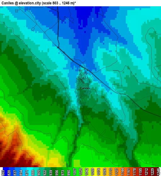
Below is the Elevation map of Caniles, which displays elevation range with different colors. Scale of the first map is from 803 to 1246 m (2635 to 4088 ft) with average elevation of 934.1 meters (=3065 ft) [note 1]
These maps also provides idea of topography and contour of this city, they are displayed at different zoom levels. More info about maps, scale and edge coordinates you can find below images.
| \ | Map #1 | Map #2 | Topo.Map |
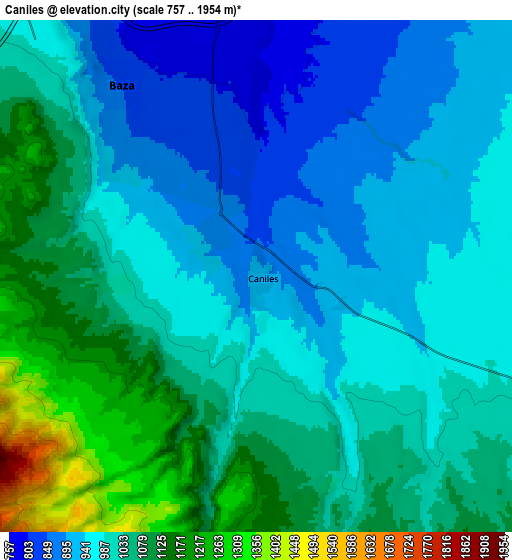
| Scale [m] | 803..1246 m | 757..1954 m | × |
| Scale [ft] | 2635..4088 ft | 2484..6411 ft | × |
| Average | 934.1 m = 3065 ft | 1012.6 m = 3322 ft | × |
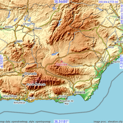
| Width | 7.76 km = 4.8 mi | 15.52 km = 9.6 mi | 248.3 km = 154.3 mi |
| Height | 7.76 km = 4.8 mi | 15.52 km = 9.6 mi | 248.3 km = 154.3 mi |
| ↑Max Latitude | 37.471596° | 37.506465° | 38.54495° |
| Latitude at center | 37.43671° | 37.43671° | 37.43671° |
| ↓Min Latitude | 37.401808° | 37.36689° | 36.31181° |
| ← Min Longitude | -2.768765° | -2.812711° | -4.13107° |
| Longitude center | -2.72482° | -2.72482° | -2.72482° |
| →Max Longitude | -2.680875° | -2.636929° | -1.31857° |
Nearby cities:
Cities around Caniles sort by population:
• Baza elevation 842 m
7.3 km,  324°
324°
• Tíjola 689 m
27.7 km,  111°
111°
• Zújar 780 m
15.7 km, 318°
• Serón 793 m
21.6 km,  118°
118°
• Cortes de Baza 701 m
24.6 km,  350°
350°
• Benamaurel 697 m
19.2 km,  5°
5°
• Cuevas del Campo 847 m
26.2 km, 316°
• Freila 817 m
19.2 km,  302°
302°
• Gor 1242 m
22.9 km,  250°
250°
• Lúcar 889 m
26.8 km,  98°
98°
• Alcóntar 963 m
15.9 km,  134°
134°
• Bayarque 817 m
28.1 km, 114°
Multilingual:
 En español:
Caniles elevación 917 m.
 En France:
Caniles élévation 917 m.


Sources and notes:
- [note 1] Map square and city borders are not equal. Map elevation data is calculated only from area inside that square.
- [src 1] Elevation data from geonames database provided with same terms of usage.
- [src 2] The elevation map of Caniles is generated using elevation data from NASA's 3 arcsec (90m) resolution SRTM data.
- [src 3] Base (background) map © OpenStreetMap contributors tiles are generated by Geofabrik and OpenTopoMap.
Copyright & License:
This Caniles Elevation Map is licensed under CC BY-SA. You may reuse any part from this page, if you give a proper credit by linking to this URL:
 More info on terms of use page.