Gor elevation
Gor (Andalusia, Provincia de Granada), Spain elevation is 1242 meters and Gor elevation in feet is 4075 ft above sea level [src 1]. Gor is a seat of a third-order administrative division (feature code) with elevation that is 639 meters (2096 ft) bigger than average city elevation in Spain.
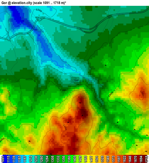
Below is the Elevation map of Gor, which displays elevation range with different colors. Scale of the first map is from 1091 to 1718 m (3579 to 5636 ft) with average elevation of 1353.9 meters (=4442 ft) [note 1]
These maps also provides idea of topography and contour of this city, they are displayed at different zoom levels. More info about maps, scale and edge coordinates you can find below images.
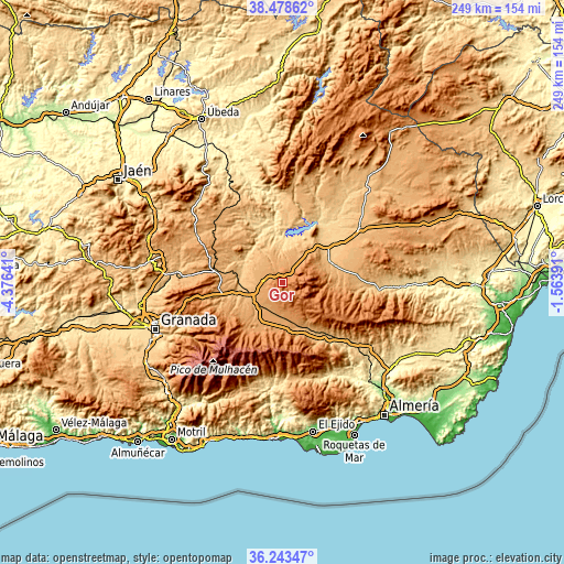
| \ | Map #1 | Topo.Map |
| Scale [m] | 1091..1718 m | × |
| Scale [ft] | 3579..5636 ft | × |
| Average | 1353.9 m = 4442 ft | × |
| Width | 7.77 km = 4.8 mi | 248.5 km = 154.4 mi |
| Height | 7.77 km = 4.8 mi | 248.5 km = 154.4 mi |
| ↑Max Latitude | 37.404287° | 38.47862° |
| Latitude at center | 37.36937° | 37.36937° |
| ↓Min Latitude | 37.334437° | 36.24347° |
| ← Min Longitude | -3.014105° | -4.37641° |
| Longitude center | -2.97016° | -2.97016° |
| →Max Longitude | -2.926215° | -1.56391° |
Nearby cities:
Cities around Gor sort by population:
• Baza elevation 842 m
22.1 km,  52°
52°
• Guadix 927 m
16.9 km,  242°
242°
• Caniles 917 m
22.9 km,  70°
70°
• Benalúa de Guadix 874 m
17.2 km,  263°
263°
• Zújar 780 m
22.4 km,  30°
30°
• Purullena 905 m
20.3 km,  253°
253°
• Huéneja 1163 m
21.5 km,  175°
175°
• Fonelas 773 m
18.4 km,  284°
284°
• Freila 817 m
18.7 km,  17°
17°
• Albuñán 1117 m
21.4 km,  222°
222°
• Marchal 937 m
22.2 km, 248°
• Ferreira 1260 m
22.6 km,  194°
194°
Multilingual:
 En español:
Gor elevación 1242 m.
 En France:
Gor élévation 1242 m.


Sources and notes:
- [note 1] Map square and city borders are not equal. Map elevation data is calculated only from area inside that square.
- [src 1] Elevation data from geonames database provided with same terms of usage.
- [src 2] The elevation map of Gor is generated using elevation data from NASA's 3 arcsec (90m) resolution SRTM data.
- [src 3] Base (background) map © OpenStreetMap contributors tiles are generated by Geofabrik and OpenTopoMap.
Copyright & License:
This Gor Elevation Map is licensed under CC BY-SA. You may reuse any part from this page, if you give a proper credit by linking to this URL:
 More info on terms of use page.