Freila elevation
Freila (Andalusia, Provincia de Granada), Spain elevation is 817 meters and Freila elevation in feet is 2680 ft above sea level [src 1]. Freila is a seat of a third-order administrative division (feature code) with elevation that is 214 meters (702 ft) bigger than average city elevation in Spain.
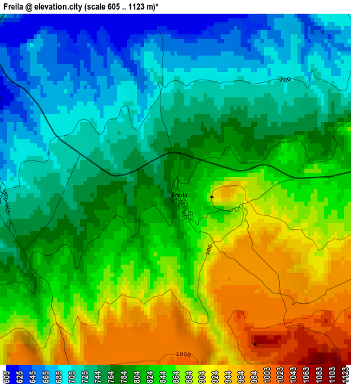
Below is the Elevation map of Freila, which displays elevation range with different colors. Scale of the first map is from 605 to 1123 m (1985 to 3684 ft) with average elevation of 805.6 meters (=2643 ft) [note 1]
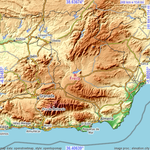
These maps also provides idea of topography and contour of this city, they are displayed at different zoom levels. More info about maps, scale and edge coordinates you can find below images.
| \ | Map #1 | Topo.Map |
| Scale [m] | 605..1123 m | × |
| Scale [ft] | 1985..3684 ft | × |
| Average | 805.6 m = 2643 ft | × |
| Width | 7.75 km = 4.8 mi | 248 km = 154.1 mi |
| Height | 7.75 km = 4.8 mi | 248 km = 154.1 mi |
| ↑Max Latitude | 37.564742° | 38.63674° |
| Latitude at center | 37.5299° | 37.5299° |
| ↓Min Latitude | 37.495042° | 36.40639° |
| ← Min Longitude | -2.952225° | -4.31453° |
| Longitude center | -2.90828° | -2.90828° |
| →Max Longitude | -2.864335° | -1.50203° |
Nearby cities:
Cities around Freila sort by population:
• Baza elevation 842 m
12.7 km,  109°
109°
• Pozo Alcón 861 m
19.3 km,  353°
353°
• Caniles 917 m
19.2 km,  122°
122°
• Zújar 780 m
6 km,  76°
76°
• Cortes de Baza 701 m
18.4 km,  40°
40°
• Benamaurel 697 m
20.1 km,  64°
64°
• Cuevas del Campo 847 m
8.8 km, 347°
• Gor 1242 m
18.7 km,  197°
197°
• Villanueva de las Torres 637 m
16.2 km,  280°
280°
• Alicún de Ortega 692 m
21.9 km,  293°
293°
• Dehesas de Guadix 687 m
18.4 km, 290°
• Hinojares 669 m
22.1 km,  339°
339°
Multilingual:
 En español:
Freila elevación 817 m.
 En France:
Freila élévation 817 m.


Sources and notes:
- [note 1] Map square and city borders are not equal. Map elevation data is calculated only from area inside that square.
- [src 1] Elevation data from geonames database provided with same terms of usage.
- [src 2] The elevation map of Freila is generated using elevation data from NASA's 3 arcsec (90m) resolution SRTM data.
- [src 3] Base (background) map © OpenStreetMap contributors tiles are generated by Geofabrik and OpenTopoMap.
Copyright & License:
This Freila Elevation Map is licensed under CC BY-SA. You may reuse any part from this page, if you give a proper credit by linking to this URL:
 More info on terms of use page.