Chilluévar elevation
Chilluévar (Andalusia, Provincia de Jaén), Spain elevation is 710 meters and Chilluévar elevation in feet is 2329 ft above sea level [src 1]. Chilluévar is a seat of a third-order administrative division (feature code) with elevation that is 107 meters (351 ft) bigger than average city elevation in Spain.
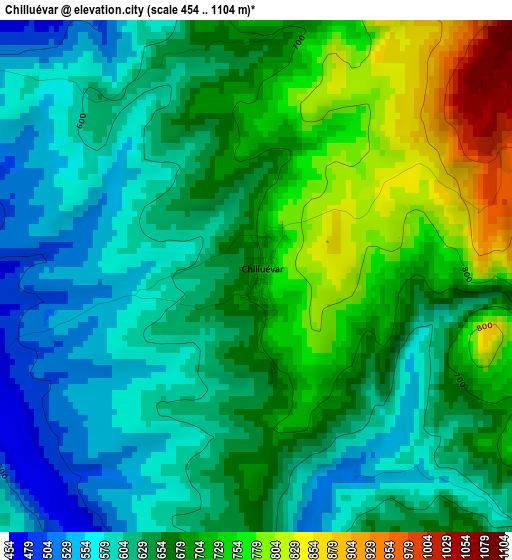
Below is the Elevation map of Chilluévar, which displays elevation range with different colors. Scale of the first map is from 454 to 1104 m (1490 to 3622 ft) with average elevation of 659.2 meters (=2163 ft) [note 1]
These maps also provides idea of topography and contour of this city, they are displayed at different zoom levels. More info about maps, scale and edge coordinates you can find below images.
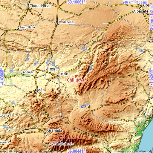
| \ | Map #1 | Topo.Map |
| Scale [m] | 454..1104 m | × |
| Scale [ft] | 1490..3622 ft | × |
| Average | 659.2 m = 2163 ft | × |
| Width | 7.7 km = 4.8 mi | 246.4 km = 153.1 mi |
| Height | 7.7 km = 4.8 mi | 246.4 km = 153.1 mi |
| ↑Max Latitude | 38.035501° | 39.10061° |
| Latitude at center | 38.00088° | 38.00088° |
| ↓Min Latitude | 37.966243° | 36.88441° |
| ← Min Longitude | -3.076345° | -4.43865° |
| Longitude center | -3.0324° | -3.0324° |
| →Max Longitude | -2.988455° | -1.62615° |
Nearby cities:
Cities around Chilluévar sort by population:
• Campiña elevation 641 m
24.7 km,  10°
10°
• Villacarrillo 799 m
13.6 km,  340°
340°
• Villanueva del Arzobispo 683 m
18.8 km, 6°
• Cazorla 809 m
9.9 km,  165°
165°
• Torreperogil 756 m
22.9 km,  279°
279°
• Quesada 656 m
17.8 km,  189°
189°
• Peal de Becerro 549 m
12.5 km,  218°
218°
• Sabiote 829 m
25.8 km,  287°
287°
• Huesa 644 m
26.6 km, 188°
• Santo Tomé 454 m
6.7 km,  297°
297°
• La Iruela 886 m
9.5 km,  160°
160°
• Iznatoraf 1031 m
17.4 km,  359°
359°
Multilingual:
 En español:
Chilluévar elevación 710 m.
 En France:
Chilluévar élévation 710 m.
 Auf Deutsch:
Chilluévar höhe über dem Meeresspiegel ist 710 m.

Sources and notes:
- [note 1] Map square and city borders are not equal. Map elevation data is calculated only from area inside that square.
- [src 1] Elevation data from geonames database provided with same terms of usage.
- [src 2] The elevation map of Chilluévar is generated using elevation data from NASA's 3 arcsec (90m) resolution SRTM data.
- [src 3] Base (background) map © OpenStreetMap contributors tiles are generated by Geofabrik and OpenTopoMap.
Copyright & License:
This Chilluévar Elevation Map is licensed under CC BY-SA. You may reuse any part from this page, if you give a proper credit by linking to this URL:
 More info on terms of use page.