Iznatoraf elevation
Iznatoraf (Andalusia, Provincia de Jaén), Spain elevation is 1031 meters and Iznatoraf elevation in feet is 3383 ft above sea level [src 1]. Iznatoraf is a seat of a third-order administrative division (feature code) with elevation that is 428 meters (1404 ft) bigger than average city elevation in Spain.
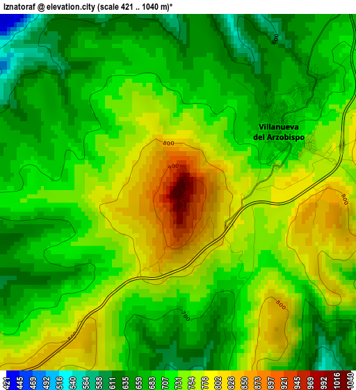
Below is the Elevation map of Iznatoraf, which displays elevation range with different colors. Scale of the first map is from 421 to 1040 m (1381 to 3412 ft) with average elevation of 722.4 meters (=2370 ft) [note 1]
These maps also provides idea of topography and contour of this city, they are displayed at different zoom levels. More info about maps, scale and edge coordinates you can find below images.
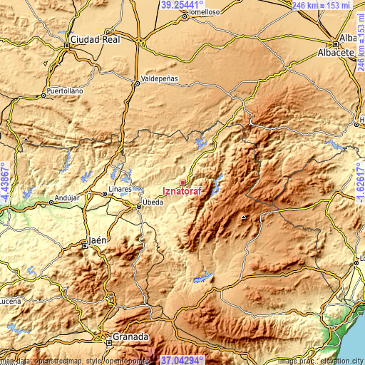
| \ | Map #1 | Topo.Map |
| Scale [m] | 421..1040 m | × |
| Scale [ft] | 1381..3412 ft | × |
| Average | 722.4 m = 2370 ft | × |
| Width | 7.68 km = 4.8 mi | 245.9 km = 152.8 mi |
| Height | 7.68 km = 4.8 mi | 245.9 km = 152.8 mi |
| ↑Max Latitude | 38.191607° | 39.25441° |
| Latitude at center | 38.15706° | 38.15706° |
| ↓Min Latitude | 38.122497° | 37.04294° |
| ← Min Longitude | -3.076365° | -4.43867° |
| Longitude center | -3.03242° | -3.03242° |
| →Max Longitude | -2.988475° | -1.62617° |
Nearby cities:
Cities around Iznatoraf sort by population:
• Campiña elevation 641 m
8.2 km,  33°
33°
• Villacarrillo 799 m
6.5 km,  224°
224°
• Villanueva del Arzobispo 683 m
2.5 km,  59°
59°
• Beas de Segura 586 m
16.4 km,  49°
49°
• Santisteban del Puerto 707 m
18.4 km,  303°
303°
• Castellar de Santisteban 763 m
13.9 km,  321°
321°
• Arroyo del Ojanco 541 m
21.8 km, 33°
• Santo Tomé 454 m
15.5 km,  202°
202°
• Montizón 643 m
21.5 km,  343°
343°
• Chilluévar 710 m
17.4 km,  179°
179°
• Chiclana de Segura 863 m
17.2 km,  357°
357°
• Sorihuela del Guadalimar 650 m
9.5 km,  348°
348°
Multilingual:
 En español:
Iznatoraf elevación 1031 m.
 En France:
Iznatoraf élévation 1031 m.
 Auf Deutsch:
Iznatoraf höhe über dem Meeresspiegel ist 1031 m.

Sources and notes:
- [note 1] Map square and city borders are not equal. Map elevation data is calculated only from area inside that square.
- [src 1] Elevation data from geonames database provided with same terms of usage.
- [src 2] The elevation map of Iznatoraf is generated using elevation data from NASA's 3 arcsec (90m) resolution SRTM data.
- [src 3] Base (background) map © OpenStreetMap contributors tiles are generated by Geofabrik and OpenTopoMap.
Copyright & License:
This Iznatoraf Elevation Map is licensed under CC BY-SA. You may reuse any part from this page, if you give a proper credit by linking to this URL:
 More info on terms of use page.