Sabiote elevation
Sabiote (Andalusia, Provincia de Jaén), Spain elevation is 829 meters and Sabiote elevation in feet is 2720 ft above sea level [src 1]. Sabiote is a populated place (feature code) with elevation that is 226 meters (741 ft) bigger than average city elevation in Spain.
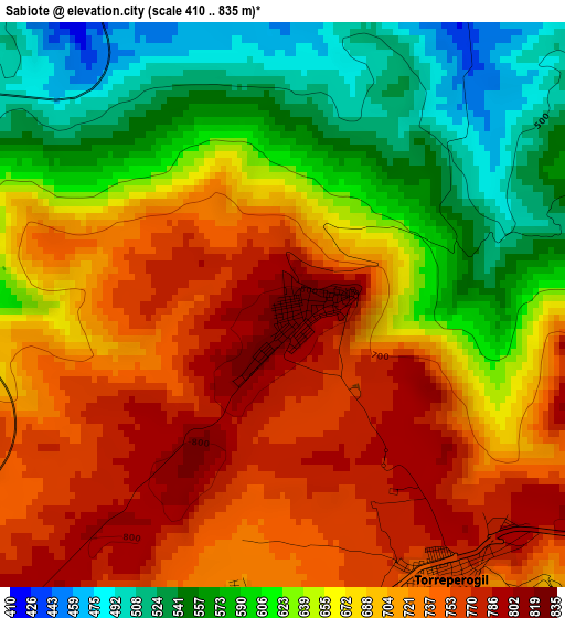
Below is the Elevation map of Sabiote, which displays elevation range with different colors. Scale of the first map is from 410 to 835 m (1345 to 2740 ft) with average elevation of 670.4 meters (=2199 ft) [note 1]
These maps also provides idea of topography and contour of this city, they are displayed at different zoom levels. More info about maps, scale and edge coordinates you can find below images.
| \ | Map #1 | Map #2 | Topo.Map |
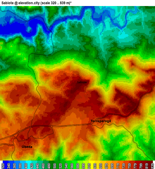
| Scale [m] | 410..835 m | 320..839 m | × |
| Scale [ft] | 1345..2740 ft | 1050..2753 ft | × |
| Average | 670.4 m = 2199 ft | 602.9 m = 1978 ft | × |
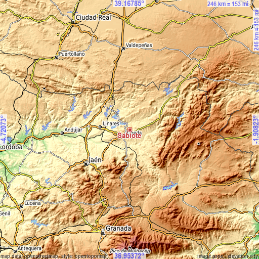
| Width | 7.69 km = 4.8 mi | 15.39 km = 9.6 mi | 246.2 km = 153 mi |
| Height | 7.69 km = 4.8 mi | 15.39 km = 9.6 mi | 246.2 km = 153 mi |
| ↑Max Latitude | 38.103749° | 38.138321° | 39.16785° |
| Latitude at center | 38.06916° | 38.06916° | 38.06916° |
| ↓Min Latitude | 38.034555° | 37.999934° | 36.95372° |
| ← Min Longitude | -3.358425° | -3.402371° | -4.72073° |
| Longitude center | -3.31448° | -3.31448° | -3.31448° |
| →Max Longitude | -3.270535° | -3.226589° | -1.90823° |
Nearby cities:
Cities around Sabiote sort by population:
• Úbeda elevation 766 m
7.9 km,  218°
218°
• Baeza 763 m
16.1 km,  238°
238°
• Villacarrillo 799 m
20.8 km,  75°
75°
• Torreperogil 756 m
4.3 km,  150°
150°
• Navas de San Juan 657 m
12.7 km,  359°
359°
• Rus 585 m
13.2 km,  259°
259°
• Begíjar 575 m
21.1 km, 243°
• Ibros 597 m
17.4 km,  252°
252°
• Santo Tomé 454 m
19.2 km,  103°
103°
• Canena 518 m
14.9 km, 261°
• Arquillos 392 m
16 km,  321°
321°
• Lupión 503 m
21.9 km, 248°
Multilingual:
 En español:
Sabiote elevación 829 m.
 En France:
Sabiote élévation 829 m.


Sources and notes:
- [note 1] Map square and city borders are not equal. Map elevation data is calculated only from area inside that square.
- [src 1] Elevation data from geonames database provided with same terms of usage.
- [src 2] The elevation map of Sabiote is generated using elevation data from NASA's 3 arcsec (90m) resolution SRTM data.
- [src 3] Base (background) map © OpenStreetMap contributors tiles are generated by Geofabrik and OpenTopoMap.
Copyright & License:
This Sabiote Elevation Map is licensed under CC BY-SA. You may reuse any part from this page, if you give a proper credit by linking to this URL:
 More info on terms of use page.