Herrera elevation
Herrera (Andalusia, Provincia de Sevilla), Spain elevation is 249 meters and Herrera elevation in feet is 817 ft above sea level [src 1]. Herrera is a seat of a third-order administrative division (feature code) with elevation that is 354 meters (1161 ft) smaller than average city elevation in Spain.
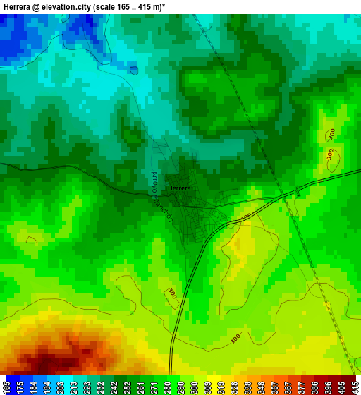
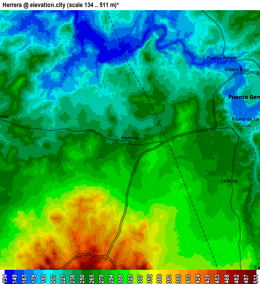
Below is the Elevation map of Herrera, which displays elevation range with different colors. Scale of the first map is from 165 to 415 m (541 to 1362 ft) with average elevation of 267.4 meters (=877 ft) [note 1]
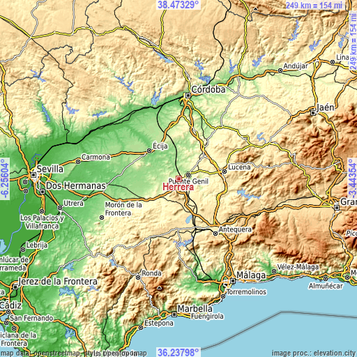
These maps also provides idea of topography and contour of this city, they are displayed at different zoom levels. More info about maps, scale and edge coordinates you can find below images.
| \ | Map #1 | Map #2 | Topo.Map |
| Scale [m] | 165..415 m | 134..511 m | × |
| Scale [ft] | 541..1362 ft | 440..1677 ft | × |
| Average | 267.4 m = 877 ft | 265.3 m = 870 ft | × |
| Width | 7.77 km = 4.8 mi | 15.53 km = 9.6 mi | 248.5 km = 154.4 mi |
| Height | 7.77 km = 4.8 mi | 15.53 km = 9.6 mi | 248.5 km = 154.4 mi |
| ↑Max Latitude | 37.398879° | 37.433783° | 38.47329° |
| Latitude at center | 37.36396° | 37.36396° | 37.36396° |
| ↓Min Latitude | 37.329024° | 37.294072° | 36.23798° |
| ← Min Longitude | -4.893735° | -4.937681° | -6.25604° |
| Longitude center | -4.84979° | -4.84979° | -4.84979° |
| →Max Longitude | -4.805845° | -4.761899° | -3.44354° |
Nearby cities:
Cities around Herrera sort by population:
• Puente-Genil elevation 215 m
7.9 km,  68°
68°
• Estepa 523 m
8.3 km,  198°
198°
• Santaella 260 m
22.1 km,  1°
1°
• Casariche 305 m
11.1 km,  134°
134°
• Pedrera 459 m
15.8 km,  194°
194°
• La Roda de Andalucía 395 m
18.9 km,  160°
160°
• Gilena 465 m
13.7 km, 204°
• El Rubio 207 m
12.3 km,  265°
265°
• Badolatosa 225 m
16.8 km,  111°
111°
• Marinaleda 204 m
9.7 km, 274°
• Aguadulce 269 m
17.7 km,  225°
225°
• Lora de Estepa 446 m
10.7 km,  169°
169°
Multilingual:
 En español:
Herrera elevación 249 m.
 En France:
Herrera élévation 249 m.


Sources and notes:
- [note 1] Map square and city borders are not equal. Map elevation data is calculated only from area inside that square.
- [src 1] Elevation data from geonames database provided with same terms of usage.
- [src 2] The elevation map of Herrera is generated using elevation data from NASA's 3 arcsec (90m) resolution SRTM data.
- [src 3] Base (background) map © OpenStreetMap contributors tiles are generated by Geofabrik and OpenTopoMap.
Copyright & License:
This Herrera Elevation Map is licensed under CC BY-SA. You may reuse any part from this page, if you give a proper credit by linking to this URL:
 More info on terms of use page.