Santaella elevation
Santaella (Andalusia, Province of Córdoba), Spain elevation is 260 meters and Santaella elevation in feet is 853 ft above sea level [src 1]. Santaella is a seat of a third-order administrative division (feature code) with elevation that is 343 meters (1125 ft) smaller than average city elevation in Spain.
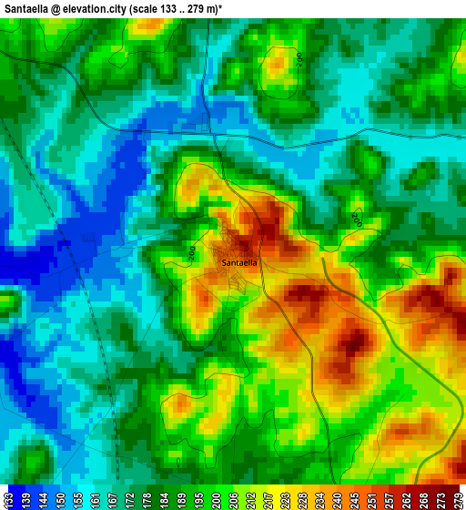
Below is the Elevation map of Santaella, which displays elevation range with different colors. Scale of the first map is from 133 to 279 m (436 to 915 ft) with average elevation of 187.3 meters (=615 ft) [note 1]
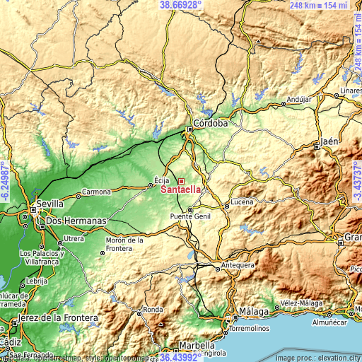
These maps also provides idea of topography and contour of this city, they are displayed at different zoom levels. More info about maps, scale and edge coordinates you can find below images.
| \ | Map #1 | Map #2 | Topo.Map |
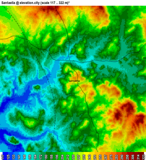
| Scale [m] | 133..279 m | 117..322 m | × |
| Scale [ft] | 436..915 ft | 384..1056 ft | × |
| Average | 187.3 m = 615 ft | 197.1 m = 647 ft | × |
| Width | 7.75 km = 4.8 mi | 15.49 km = 9.6 mi | 247.9 km = 154 mi |
| Height | 7.75 km = 4.8 mi | 15.49 km = 9.6 mi | 247.9 km = 154 mi |
| ↑Max Latitude | 37.597767° | 37.632577° | 38.66928° |
| Latitude at center | 37.56294° | 37.56294° | 37.56294° |
| ↓Min Latitude | 37.528097° | 37.493238° | 36.43992° |
| ← Min Longitude | -4.887565° | -4.931511° | -6.24987° |
| Longitude center | -4.84362° | -4.84362° | -4.84362° |
| →Max Longitude | -4.799675° | -4.755729° | -3.43737° |
Nearby cities:
Cities around Santaella sort by population:
• Écija elevation 105 m
21.2 km,  263°
263°
• Puente-Genil 215 m
20.4 km,  160°
160°
• Montilla 382 m
18.3 km,  81°
81°
• Aguilar 370 m
17.3 km,  108°
108°
• La Carlota 213 m
14.5 km,  327°
327°
• Fernán-Núñez 325 m
15.8 km,  40°
40°
• La Rambla 334 m
10.4 km,  61°
61°
• Herrera 249 m
22.1 km,  181°
181°
• Montalbán de Córdoba 270 m
8.5 km, 77°
• Montemayor 368 m
15.9 km,  53°
53°
• La Victoria 267 m
13.2 km,  356°
356°
• San Sebastián de los Ballesteros 310 m
10.2 km,  9°
9°
Multilingual:
 En español:
Santaella elevación 260 m.
 En France:
Santaella élévation 260 m.
 Auf Deutsch:
Santaella höhe über dem Meeresspiegel ist 260 m.

Sources and notes:
- [note 1] Map square and city borders are not equal. Map elevation data is calculated only from area inside that square.
- [src 1] Elevation data from geonames database provided with same terms of usage.
- [src 2] The elevation map of Santaella is generated using elevation data from NASA's 3 arcsec (90m) resolution SRTM data.
- [src 3] Base (background) map © OpenStreetMap contributors tiles are generated by Geofabrik and OpenTopoMap.
Copyright & License:
This Santaella Elevation Map is licensed under CC BY-SA. You may reuse any part from this page, if you give a proper credit by linking to this URL:
 More info on terms of use page.