Aguilar elevation
Aguilar (Andalusia, Province of Córdoba), Spain elevation is 370 meters and Aguilar elevation in feet is 1214 ft above sea level [src 1]. Aguilar is a seat of a third-order administrative division (feature code) with elevation that is 233 meters (764 ft) smaller than average city elevation in Spain.
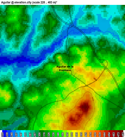
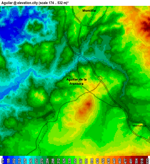
Below is the Elevation map of Aguilar, which displays elevation range with different colors. Scale of the first map is from 228 to 483 m (748 to 1585 ft) with average elevation of 319.3 meters (=1048 ft) [note 1]
These maps also provides idea of topography and contour of this city, they are displayed at different zoom levels. More info about maps, scale and edge coordinates you can find below images.
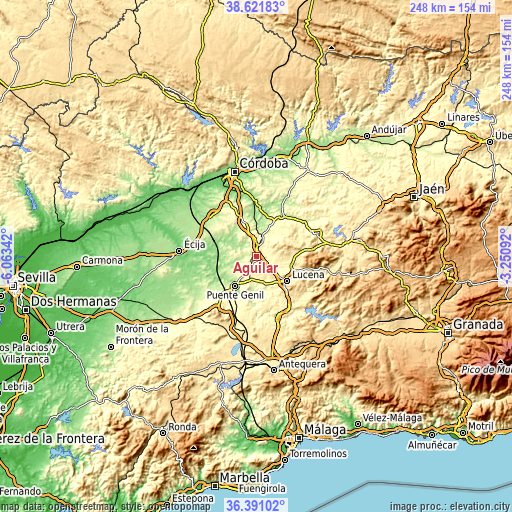
| \ | Map #1 | Map #2 | Topo.Map |
| Scale [m] | 228..483 m | 174..532 m | × |
| Scale [ft] | 748..1585 ft | 571..1745 ft | × |
| Average | 319.3 m = 1048 ft | 316.4 m = 1038 ft | × |
| Width | 7.75 km = 4.8 mi | 15.5 km = 9.6 mi | 248 km = 154.1 mi |
| Height | 7.75 km = 4.8 mi | 15.5 km = 9.6 mi | 248 km = 154.1 mi |
| ↑Max Latitude | 37.549609° | 37.584442° | 38.62183° |
| Latitude at center | 37.51476° | 37.51476° | 37.51476° |
| ↓Min Latitude | 37.479895° | 37.445013° | 36.39102° |
| ← Min Longitude | -4.701115° | -4.745061° | -6.06342° |
| Longitude center | -4.65717° | -4.65717° | -4.65717° |
| →Max Longitude | -4.613225° | -4.569279° | -3.25092° |
Nearby cities:
Cities around Aguilar sort by population:
• Lucena elevation 493 m
19.2 km,  127°
127°
• Puente-Genil 215 m
17 km,  214°
214°
• Montilla 382 m
8.1 km,  11°
11°
• Cabra 458 m
19.6 km,  103°
103°
• Fernán-Núñez 325 m
18.4 km,  340°
340°
• La Rambla 334 m
12.6 km,  324°
324°
• Santaella 260 m
17.3 km,  288°
288°
• Nueva-Carteya 437 m
18.5 km,  64°
64°
• Montalbán de Córdoba 270 m
10.9 km,  311°
311°
• Montemayor 368 m
15.2 km,  346°
346°
• Monturque 370 m
8.2 km, 125°
• Moriles 381 m
9.7 km,  153°
153°
Multilingual:
 En español:
Aguilar elevación 370 m.
 En France:
Aguilar élévation 370 m.


Sources and notes:
- [note 1] Map square and city borders are not equal. Map elevation data is calculated only from area inside that square.
- [src 1] Elevation data from geonames database provided with same terms of usage.
- [src 2] The elevation map of Aguilar is generated using elevation data from NASA's 3 arcsec (90m) resolution SRTM data.
- [src 3] Base (background) map © OpenStreetMap contributors tiles are generated by Geofabrik and OpenTopoMap.
Copyright & License:
This Aguilar Elevation Map is licensed under CC BY-SA. You may reuse any part from this page, if you give a proper credit by linking to this URL:
 More info on terms of use page.