La Roda de Andalucía elevation
La Roda de Andalucía (Andalusia, Provincia de Sevilla), Spain elevation is 395 meters and La Roda de Andalucía elevation in feet is 1296 ft above sea level [src 1]. La Roda de Andalucía is a populated place (feature code) with elevation that is 208 meters (682 ft) smaller than average city elevation in Spain.
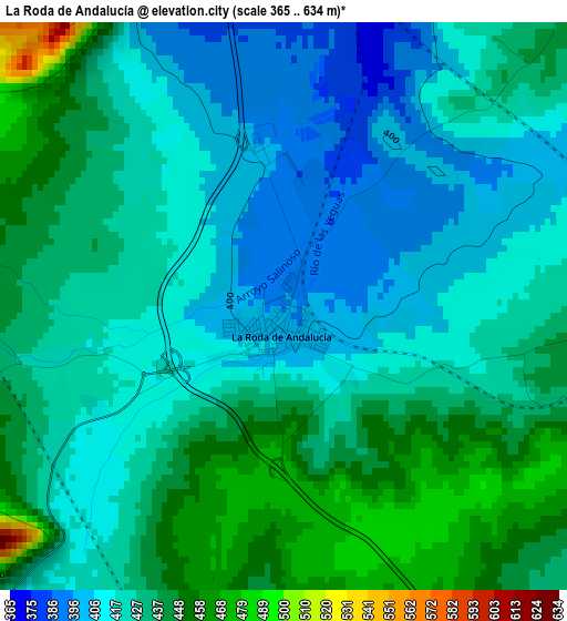
Below is the Elevation map of La Roda de Andalucía, which displays elevation range with different colors. Scale of the first map is from 365 to 634 m (1198 to 2080 ft) with average elevation of 426.7 meters (=1400 ft) [note 1]
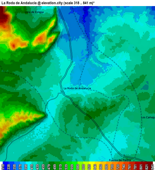
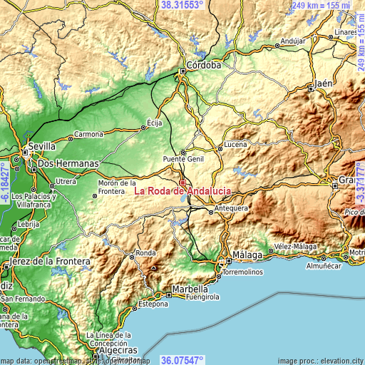
These maps also provides idea of topography and contour of this city, they are displayed at different zoom levels. More info about maps, scale and edge coordinates you can find below images.
| \ | Map #1 | Map #2 | Topo.Map |
| Scale [m] | 365..634 m | 318..841 m | × |
| Scale [ft] | 1198..2080 ft | 1043..2759 ft | × |
| Average | 426.7 m = 1400 ft | 450.9 m = 1479 ft | × |
| Width | 7.78 km = 4.8 mi | 15.57 km = 9.7 mi | 249.1 km = 154.8 mi |
| Height | 7.78 km = 4.8 mi | 15.57 km = 9.7 mi | 249.1 km = 154.8 mi |
| ↑Max Latitude | 37.238804° | 37.273782° | 38.31553° |
| Latitude at center | 37.20381° | 37.20381° | 37.20381° |
| ↓Min Latitude | 37.1688° | 37.133774° | 36.07547° |
| ← Min Longitude | -4.821965° | -4.865911° | -6.18427° |
| Longitude center | -4.77802° | -4.77802° | -4.77802° |
| →Max Longitude | -4.734075° | -4.690129° | -3.37177° |
Nearby cities:
Cities around La Roda de Andalucía sort by population:
• Estepa elevation 523 m
13.3 km,  317°
317°
• Casariche 305 m
10.1 km,  9°
9°
• Alameda 430 m
10.6 km,  87°
87°
• Pedrera 459 m
10.6 km,  283°
283°
• Mollina 475 m
13.8 km,  129°
129°
• Gilena 465 m
13.2 km,  293°
293°
• Sierra de Yeguas 454 m
11.9 km,  221°
221°
• Badolatosa 225 m
14.8 km,  38°
38°
• Humilladero 448 m
12 km,  146°
146°
• Fuente de Piedra 444 m
8.7 km, 150°
• Palenciana 395 m
18 km,  73°
73°
• Lora de Estepa 446 m
8.5 km,  328°
328°
Multilingual:
 En español:
La Roda de Andalucía elevación 395 m.
 En France:
La Roda de Andalucía élévation 395 m.
 Auf Deutsch:
La Roda de Andalucía höhe über dem Meeresspiegel ist 395 m.
 На русском:
La Roda de Andalucía высота над уровнем моря 395 м
Sources and notes:
- [note 1] Map square and city borders are not equal. Map elevation data is calculated only from area inside that square.
- [src 1] Elevation data from geonames database provided with same terms of usage.
- [src 2] The elevation map of La Roda de Andalucía is generated using elevation data from NASA's 3 arcsec (90m) resolution SRTM data.
- [src 3] Base (background) map © OpenStreetMap contributors tiles are generated by Geofabrik and OpenTopoMap.
Copyright & License:
This La Roda de Andalucía Elevation Map is licensed under CC BY-SA. You may reuse any part from this page, if you give a proper credit by linking to this URL:
 More info on terms of use page.