Lora de Estepa elevation
Lora de Estepa (Andalusia, Provincia de Sevilla), Spain elevation is 446 meters and Lora de Estepa elevation in feet is 1463 ft above sea level [src 1]. Lora de Estepa is a seat of a third-order administrative division (feature code) with elevation that is 157 meters (515 ft) smaller than average city elevation in Spain.
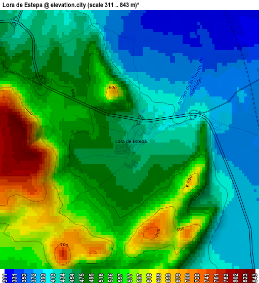
Below is the Elevation map of Lora de Estepa, which displays elevation range with different colors. Scale of the first map is from 311 to 843 m (1020 to 2766 ft) with average elevation of 486.3 meters (=1595 ft) [note 1]
These maps also provides idea of topography and contour of this city, they are displayed at different zoom levels. More info about maps, scale and edge coordinates you can find below images.
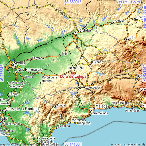
| \ | Map #1 | Topo.Map |
| Scale [m] | 311..843 m | × |
| Scale [ft] | 1020..2766 ft | × |
| Average | 486.3 m = 1595 ft | × |
| Width | 7.78 km = 4.8 mi | 248.9 km = 154.7 mi |
| Height | 7.78 km = 4.8 mi | 248.9 km = 154.7 mi |
| ↑Max Latitude | 37.304223° | 38.38001° |
| Latitude at center | 37.26926° | 37.26926° |
| ↓Min Latitude | 37.23428° | 36.14188° |
| ← Min Longitude | -4.871535° | -6.23384° |
| Longitude center | -4.82759° | -4.82759° |
| →Max Longitude | -4.783645° | -3.42134° |
Nearby cities:
Cities around Lora de Estepa sort by population:
• Puente-Genil elevation 215 m
14.4 km,  21°
21°
• Estepa 523 m
5.2 km,  299°
299°
• Herrera 249 m
10.7 km,  349°
349°
• Casariche 305 m
6.6 km,  65°
65°
• Alameda 430 m
16.4 km,  114°
114°
• Pedrera 459 m
7.6 km,  230°
230°
• La Roda de Andalucía 395 m
8.5 km,  148°
148°
• Gilena 465 m
7.9 km,  255°
255°
• Sierra de Yeguas 454 m
16.5 km,  192°
192°
• Badolatosa 225 m
14.3 km, 72°
• Marinaleda 204 m
16.3 km,  314°
314°
• Aguadulce 269 m
14.7 km, 262°
Multilingual:
 En español:
Lora de Estepa elevación 446 m.
 En France:
Lora de Estepa élévation 446 m.
 Auf Deutsch:
Lora de Estepa höhe über dem Meeresspiegel ist 446 m.

Sources and notes:
- [note 1] Map square and city borders are not equal. Map elevation data is calculated only from area inside that square.
- [src 1] Elevation data from geonames database provided with same terms of usage.
- [src 2] The elevation map of Lora de Estepa is generated using elevation data from NASA's 3 arcsec (90m) resolution SRTM data.
- [src 3] Base (background) map © OpenStreetMap contributors tiles are generated by Geofabrik and OpenTopoMap.
Copyright & License:
This Lora de Estepa Elevation Map is licensed under CC BY-SA. You may reuse any part from this page, if you give a proper credit by linking to this URL:
 More info on terms of use page.