Jijona elevation
Jijona (Valencia, Provincia de Alicante), Spain elevation is 446 meters and Jijona elevation in feet is 1463 ft above sea level [src 1]. Jijona is a populated place (feature code) with elevation that is 157 meters (515 ft) smaller than average city elevation in Spain.
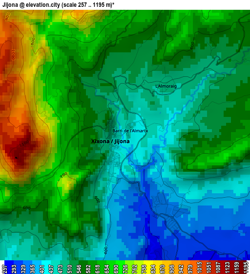
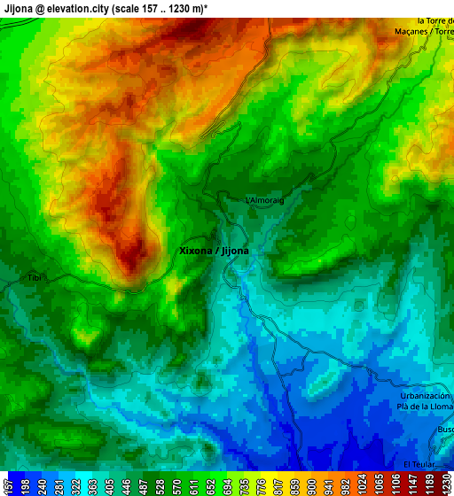
Below is the Elevation map of Jijona, which displays elevation range with different colors. Scale of the first map is from 257 to 1195 m (843 to 3921 ft) with average elevation of 564.7 meters (=1853 ft) [note 1]
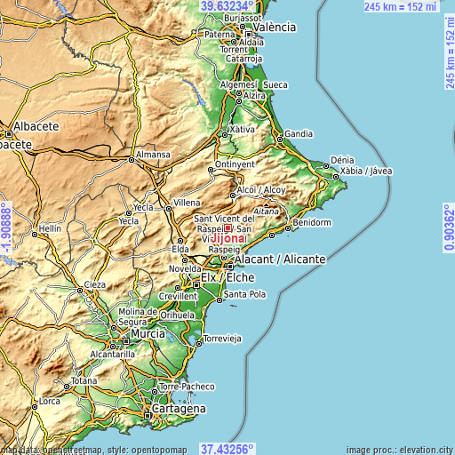
These maps also provides idea of topography and contour of this city, they are displayed at different zoom levels. More info about maps, scale and edge coordinates you can find below images.
| \ | Map #1 | Map #2 | Topo.Map |
| Scale [m] | 257..1195 m | 157..1230 m | × |
| Scale [ft] | 843..3921 ft | 515..4035 ft | × |
| Average | 564.7 m = 1853 ft | 584.7 m = 1918 ft | × |
| Width | 7.64 km = 4.7 mi | 15.29 km = 9.5 mi | 244.6 km = 152 mi |
| Height | 7.64 km = 4.7 mi | 15.29 km = 9.5 mi | 244.6 km = 152 mi |
| ↑Max Latitude | 38.575224° | 38.609572° | 39.63234° |
| Latitude at center | 38.54086° | 38.54086° | 38.54086° |
| ↓Min Latitude | 38.506479° | 38.472082° | 37.43256° |
| ← Min Longitude | -0.546575° | -0.590521° | -1.90888° |
| Longitude center | -0.50263° | -0.50263° | -0.50263° |
| →Max Longitude | -0.458685° | -0.414739° | 0.90362° |
Nearby cities:
Cities around Jijona sort by population:
• San Vicent del Raspeig elevation 113 m
16.2 km,  187°
187°
• El Campello 24 m
15.4 km,  143°
143°
• Ibi 748 m
11.2 km,  327°
327°
• Mutxamel 70 m
14.8 km,  160°
160°
• San Juan de Alicante 44 m
16.5 km, 159°
• Castalla 700 m
16 km,  292°
292°
• Agost 350 m
16.3 km,  226°
226°
• Busot 334 m
9.8 km,  132°
132°
• Tibi 534 m
6.6 km,  260°
260°
• Relleu 431 m
17.4 km,  72°
72°
• Benifallim 740 m
16.2 km,  33°
33°
• Aigües 301 m
14 km,  108°
108°
Multilingual:
 En español:
Jijona elevación 446 m.
 En France:
Jijona élévation 446 m.


Sources and notes:
- [note 1] Map square and city borders are not equal. Map elevation data is calculated only from area inside that square.
- [src 1] Elevation data from geonames database provided with same terms of usage.
- [src 2] The elevation map of Jijona is generated using elevation data from NASA's 3 arcsec (90m) resolution SRTM data.
- [src 3] Base (background) map © OpenStreetMap contributors tiles are generated by Geofabrik and OpenTopoMap.
Copyright & License:
This Jijona Elevation Map is licensed under CC BY-SA. You may reuse any part from this page, if you give a proper credit by linking to this URL:
 More info on terms of use page.