Castalla elevation
Castalla (Valencia, Provincia de Alicante), Spain elevation is 700 meters and Castalla elevation in feet is 2297 ft above sea level [src 1]. Castalla is a seat of a third-order administrative division (feature code) with elevation that is 97 meters (318 ft) bigger than average city elevation in Spain.
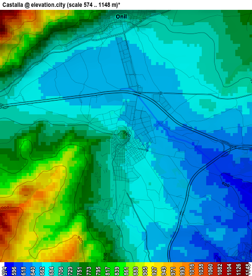
Below is the Elevation map of Castalla, which displays elevation range with different colors. Scale of the first map is from 574 to 1148 m (1883 to 3766 ft) with average elevation of 720.5 meters (=2364 ft) [note 1]
These maps also provides idea of topography and contour of this city, they are displayed at different zoom levels. More info about maps, scale and edge coordinates you can find below images.
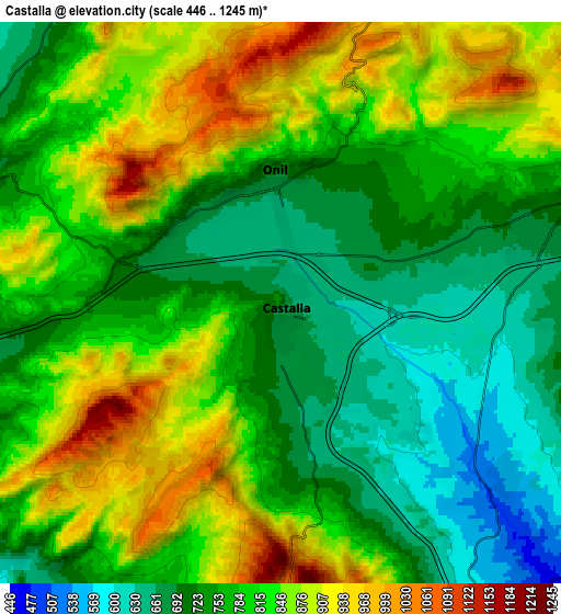
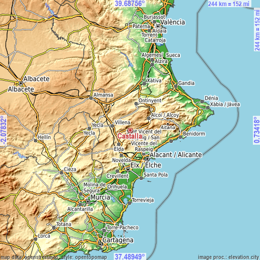
| \ | Map #1 | Map #2 | Topo.Map |
| Scale [m] | 574..1148 m | 446..1245 m | × |
| Scale [ft] | 1883..3766 ft | 1463..4085 ft | × |
| Average | 720.5 m = 2364 ft | 791.8 m = 2598 ft | × |
| Width | 7.64 km = 4.7 mi | 15.28 km = 9.5 mi | 244.4 km = 151.9 mi |
| Height | 7.64 km = 4.7 mi | 15.28 km = 9.5 mi | 244.4 km = 151.9 mi |
| ↑Max Latitude | 38.631277° | 38.665598° | 39.68756° |
| Latitude at center | 38.59694° | 38.59694° | 38.59694° |
| ↓Min Latitude | 38.562586° | 38.528216° | 37.48949° |
| ← Min Longitude | -0.716015° | -0.759961° | -2.07832° |
| Longitude center | -0.67207° | -0.67207° | -0.67207° |
| →Max Longitude | -0.628125° | -0.584179° | 0.73418° |
Nearby cities:
Cities around Castalla sort by population:
• Elda elevation 412 m
16.8 km,  218°
218°
• Villena 525 m
17.4 km,  284°
284°
• Ibi 748 m
9.2 km,  69°
69°
• Sax 480 m
14.3 km,  242°
242°
• Onil 676 m
3.2 km,  358°
358°
• Jijona 446 m
16 km,  112°
112°
• Agost 350 m
17.7 km,  170°
170°
• Bocairent 668 m
19.5 km,  14°
14°
• Biar 723 m
8.9 km,  295°
295°
• Beneixama 596 m
14.1 km,  324°
324°
• Tibi 534 m
11 km,  131°
131°
• Cañada 561 m
15 km, 304°
Multilingual:
 En español:
Castalla elevación 700 m.
 En France:
Castalla élévation 700 m.
 Auf Deutsch:
Castalla höhe über dem Meeresspiegel ist 700 m.

Sources and notes:
- [note 1] Map square and city borders are not equal. Map elevation data is calculated only from area inside that square.
- [src 1] Elevation data from geonames database provided with same terms of usage.
- [src 2] The elevation map of Castalla is generated using elevation data from NASA's 3 arcsec (90m) resolution SRTM data.
- [src 3] Base (background) map © OpenStreetMap contributors tiles are generated by Geofabrik and OpenTopoMap.
Copyright & License:
This Castalla Elevation Map is licensed under CC BY-SA. You may reuse any part from this page, if you give a proper credit by linking to this URL:
 More info on terms of use page.