Relleu elevation
Relleu (Valencia, Provincia de Alicante), Spain elevation is 431 meters and Relleu elevation in feet is 1414 ft above sea level [src 1]. Relleu is a seat of a third-order administrative division (feature code) with elevation that is 172 meters (564 ft) smaller than average city elevation in Spain.
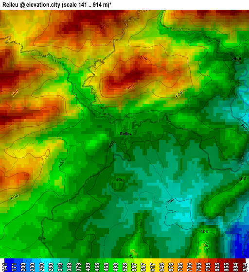
Below is the Elevation map of Relleu, which displays elevation range with different colors. Scale of the first map is from 141 to 914 m (463 to 2999 ft) with average elevation of 507.2 meters (=1664 ft) [note 1]
These maps also provides idea of topography and contour of this city, they are displayed at different zoom levels. More info about maps, scale and edge coordinates you can find below images.
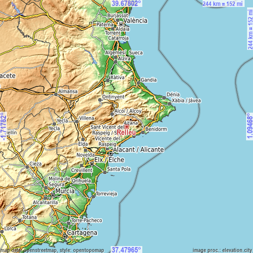
| \ | Map #1 | Topo.Map |
| Scale [m] | 141..914 m | × |
| Scale [ft] | 463..2999 ft | × |
| Average | 507.2 m = 1664 ft | × |
| Width | 7.64 km = 4.7 mi | 244.4 km = 151.9 mi |
| Height | 7.64 km = 4.7 mi | 244.4 km = 151.9 mi |
| ↑Max Latitude | 38.621592° | 39.67802° |
| Latitude at center | 38.58725° | 38.58725° |
| ↓Min Latitude | 38.552892° | 37.47965° |
| ← Min Longitude | -0.355515° | -1.71782° |
| Longitude center | -0.31157° | -0.31157° |
| →Max Longitude | -0.267625° | 1.09468° |
Nearby cities:
Cities around Relleu sort by population:
• Villajoyosa elevation 39 m
11.2 km,  142°
142°
• Finestrat 262 m
8.9 km,  104°
104°
• Busot 334 m
15 km,  218°
218°
• Orcheta 198 m
5 km,  121°
121°
• Benilloba 541 m
14.3 km,  331°
331°
• Sella 426 m
4.1 km,  53°
53°
• Benimantell 544 m
13.3 km,  41°
41°
• Confrides 786 m
11.4 km,  18°
18°
• Benasau 707 m
11.8 km,  346°
346°
• Beniardá 468 m
13.6 km, 37°
• Benifallim 740 m
11.4 km,  317°
317°
• Aigües 301 m
10.3 km,  199°
199°
Multilingual:
 En español:
Relleu elevación 431 m.
 En France:
Relleu élévation 431 m.


Sources and notes:
- [note 1] Map square and city borders are not equal. Map elevation data is calculated only from area inside that square.
- [src 1] Elevation data from geonames database provided with same terms of usage.
- [src 2] The elevation map of Relleu is generated using elevation data from NASA's 3 arcsec (90m) resolution SRTM data.
- [src 3] Base (background) map © OpenStreetMap contributors tiles are generated by Geofabrik and OpenTopoMap.
Copyright & License:
This Relleu Elevation Map is licensed under CC BY-SA. You may reuse any part from this page, if you give a proper credit by linking to this URL:
 More info on terms of use page.