La Maná elevation
La Maná (Cotopaxi), Ecuador elevation is 212 meters and La Maná elevation in feet is 696 ft above sea level [src 1]. La Maná is a populated place (feature code) with elevation that is 733 meters (2405 ft) smaller than average city elevation in Ecuador.
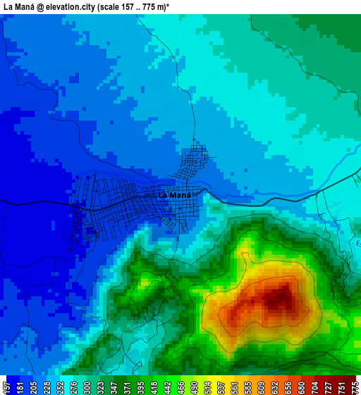
Below is the Elevation map of La Maná, which displays elevation range with different colors. Scale of the first map is from 157 to 775 m (515 to 2543 ft) with average elevation of 284 meters (=932 ft) [note 1]
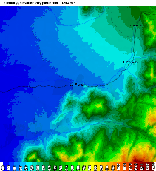
These maps also provides idea of topography and contour of this city, they are displayed at different zoom levels. More info about maps, scale and edge coordinates you can find below images.
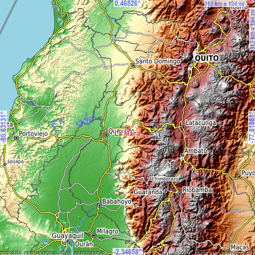
| \ | Map #1 | Map #2 | Topo.Map |
| Scale [m] | 157..775 m | 109..1303 m | × |
| Scale [ft] | 515..2543 ft | 358..4275 ft | × |
| Average | 284 m = 932 ft | 347.8 m = 1141 ft | × |
| Width | 9.77 km = 6.1 mi | 19.54 km = 12.1 mi | 312.6 km = 194.2 mi |
| Height | 9.77 km = 6.1 mi | 19.54 km = 12.1 mi | 312.7 km = 194.3 mi |
| ↑Max Latitude | -0.897° | -0.85306° | 0.46526° |
| Latitude at center | -0.94094° | -0.94094° | -0.94094° |
| ↓Min Latitude | -0.984879° | -1.028818° | -2.34658° |
| ← Min Longitude | -79.269005° | -79.312951° | -80.63131° |
| Longitude center | -79.22506° | -79.22506° | -79.22506° |
| →Max Longitude | -79.181115° | -79.137169° | -77.81881° |
Nearby cities:
Cities around La Maná sort by population:
• Santo Domingo de los Colorados elevation 554 m
76.7 km,  4°
4°
• Ambato 2597 m
75.8 km,  116°
116°
• Quevedo 51 m
28.2 km,  249°
249°
• Latacunga 2769 m
67.8 km,  89°
89°
• Velasco Ibarra 75 m
47.3 km,  256°
256°
• Ventanas 24 m
61.5 km,  205°
205°
• Guaranda 2680 m
76.6 km,  161°
161°
• Pujilí 2944 m
58.8 km, 91°
• San Miguel de Salcedo 2650 m
71.5 km,  99°
99°
• Catarama 17 m
75.2 km,  200°
200°
• Píllaro 2787 m
79.7 km,  108°
108°
• Saquisilí 2919 m
63.1 km,  79°
79°
Multilingual:
 En español:
La Maná elevación 212 m.
 En France:
La Maná élévation 212 m.


Sources and notes:
- [note 1] Map square and city borders are not equal. Map elevation data is calculated only from area inside that square.
- [src 1] Elevation data from geonames database provided with same terms of usage.
- [src 2] The elevation map of La Maná is generated using elevation data from NASA's 3 arcsec (90m) resolution SRTM data.
- [src 3] Base (background) map © OpenStreetMap contributors tiles are generated by Geofabrik and OpenTopoMap.
Copyright & License:
This La Maná Elevation Map is licensed under CC BY-SA. You may reuse any part from this page, if you give a proper credit by linking to this URL:
 More info on terms of use page.