Quevedo elevation
Quevedo (Los Ríos, Cantón Quevedo), Ecuador elevation is 51 meters and Quevedo elevation in feet is 167 ft above sea level [src 1]. Quevedo is a populated place (feature code) with elevation that is 894 meters (2933 ft) smaller than average city elevation in Ecuador.
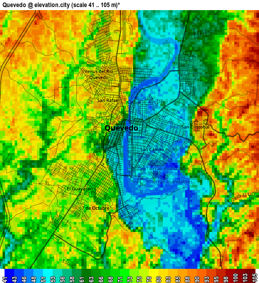
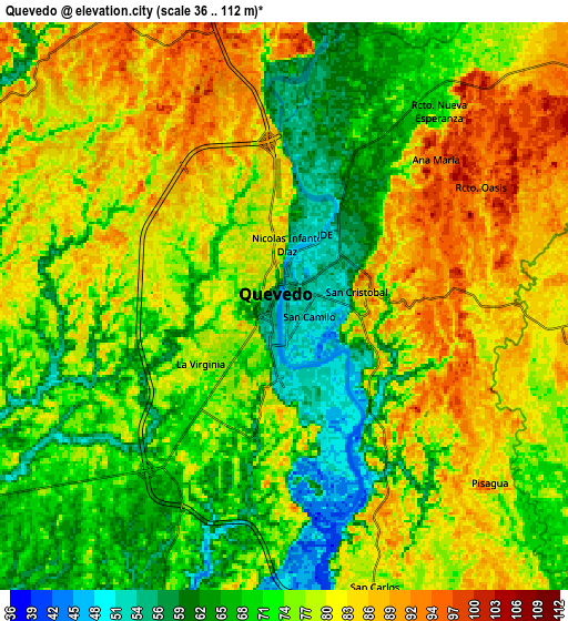
Below is the Elevation map of Quevedo, which displays elevation range with different colors. Scale of the first map is from 41 to 105 m (135 to 344 ft) with average elevation of 70.6 meters (=232 ft) [note 1]
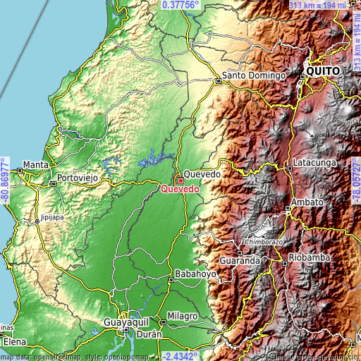
These maps also provides idea of topography and contour of this city, they are displayed at different zoom levels. More info about maps, scale and edge coordinates you can find below images.
| \ | Map #1 | Map #2 | Topo.Map |
| Scale [m] | 41..105 m | 36..112 m | × |
| Scale [ft] | 135..344 ft | 118..367 ft | × |
| Average | 70.6 m = 232 ft | 75.7 m = 248 ft | × |
| Width | 9.77 km = 6.1 mi | 19.54 km = 12.1 mi | 312.6 km = 194.2 mi |
| Height | 9.77 km = 6.1 mi | 19.54 km = 12.1 mi | 312.7 km = 194.3 mi |
| ↑Max Latitude | -0.984691° | -0.940752° | 0.37756° |
| Latitude at center | -1.02863° | -1.02863° | -1.02863° |
| ↓Min Latitude | -1.072568° | -1.116505° | -2.4342° |
| ← Min Longitude | -79.507465° | -79.551411° | -80.86977° |
| Longitude center | -79.46352° | -79.46352° | -79.46352° |
| →Max Longitude | -79.419575° | -79.375629° | -78.05727° |
Nearby cities:
Cities around Quevedo sort by population:
• Velasco Ibarra elevation 75 m
19.5 km,  265°
265°
• Ventanas 24 m
45.9 km,  179°
179°
• Chone 16 m
79.1 km,  297°
297°
• Balzar 41 m
61.7 km,  232°
232°
• Vinces 17 m
66.8 km,  208°
208°
• Guaranda 2680 m
81.1 km,  140°
140°
• Calceta 23 m
80.5 km,  284°
284°
• La Maná 212 m
28.2 km,  69°
69°
• Catarama 17 m
60.8 km, 179°
• Junín 49 m
83.3 km, 277°
• Palenque 31 m
56 km,  215°
215°
• Wilfrido Loor Moreira 164 m
78.3 km,  343°
343°
Multilingual:
 En español:
Quevedo elevación 51 m.
 En France:
Quevedo élévation 51 m.


Sources and notes:
- [note 1] Map square and city borders are not equal. Map elevation data is calculated only from area inside that square.
- [src 1] Elevation data from geonames database provided with same terms of usage.
- [src 2] The elevation map of Quevedo is generated using elevation data from NASA's 3 arcsec (90m) resolution SRTM data.
- [src 3] Base (background) map © OpenStreetMap contributors tiles are generated by Geofabrik and OpenTopoMap.
Copyright & License:
This Quevedo Elevation Map is licensed under CC BY-SA. You may reuse any part from this page, if you give a proper credit by linking to this URL:
 More info on terms of use page.