Guaranda elevation
Guaranda (Bolívar, Cantón Guaranda), Ecuador elevation is 2680 meters and Guaranda elevation in feet is 8793 ft above sea level [src 1]. Guaranda is a seat of a first-order administrative division (feature code) with elevation that is 1735 meters (5692 ft) bigger than average city elevation in Ecuador.
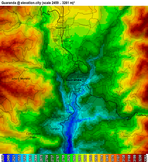
Below is the Elevation map of Guaranda, which displays elevation range with different colors. Scale of the first map is from 2459 to 3261 m (8068 to 10699 ft) with average elevation of 2863.4 meters (=9394 ft) [note 1]
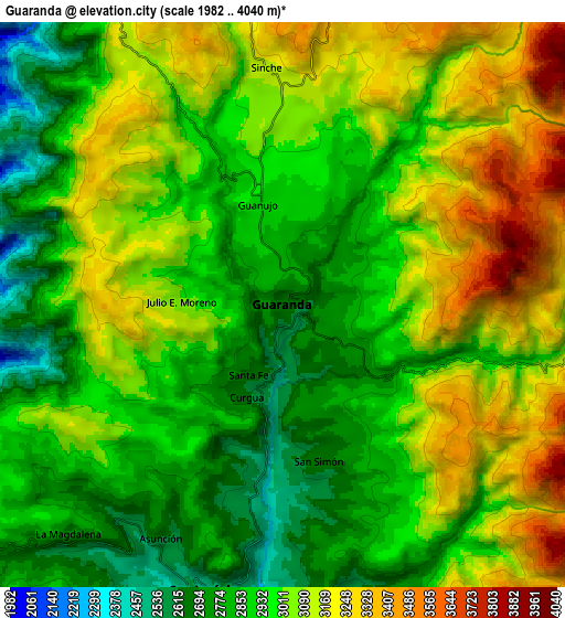
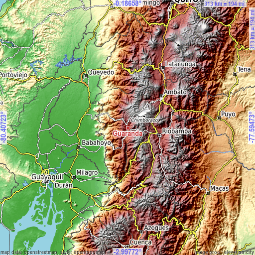
These maps also provides idea of topography and contour of this city, they are displayed at different zoom levels. More info about maps, scale and edge coordinates you can find below images.
| \ | Map #1 | Map #2 | Topo.Map |
| Scale [m] | 2459..3261 m | 1982..4040 m | × |
| Scale [ft] | 8068..10699 ft | 6503..13255 ft | × |
| Average | 2863.4 m = 9394 ft | 2986.9 m = 9800 ft | × |
| Width | 9.77 km = 6.1 mi | 19.54 km = 12.1 mi | 312.6 km = 194.2 mi |
| Height | 9.77 km = 6.1 mi | 19.54 km = 12.1 mi | 312.6 km = 194.2 mi |
| ↑Max Latitude | -1.548701° | -1.504771° | -0.18658° |
| Latitude at center | -1.59263° | -1.59263° | -1.59263° |
| ↓Min Latitude | -1.636558° | -1.680485° | -2.99772° |
| ← Min Longitude | -79.044925° | -79.088871° | -80.40723° |
| Longitude center | -79.00098° | -79.00098° | -79.00098° |
| →Max Longitude | -78.957035° | -78.913089° | -77.59473° |
Nearby cities:
Cities around Guaranda sort by population:
• Ambato elevation 2597 m
57.3 km,  48°
48°
• Riobamba 2758 m
40.3 km,  102°
102°
• Babahoyo 10 m
63.7 km,  248°
248°
• Ventanas 24 m
53.7 km,  288°
288°
• Pelileo 2589 m
58.7 km,  60°
60°
• Montalvo 65 m
38.7 km,  235°
235°
• Guano 2666 m
41.2 km,  92°
92°
• Alfredo Baquerizo Moreno 9 m
67.7 km, 237°
• San Miguel 2444 m
13.7 km,  199°
199°
• Catarama 17 m
51.1 km,  272°
272°
• Baños 1805 m
67.8 km,  71°
71°
• Quero 2962 m
49.6 km, 61°
Multilingual:
 En español:
Guaranda elevación 2680 m.
 En France:
Guaranda élévation 2680 m.
 Auf Deutsch:
Guaranda höhe über dem Meeresspiegel ist 2680 m.

Sources and notes:
- [note 1] Map square and city borders are not equal. Map elevation data is calculated only from area inside that square.
- [src 1] Elevation data from geonames database provided with same terms of usage.
- [src 2] The elevation map of Guaranda is generated using elevation data from NASA's 3 arcsec (90m) resolution SRTM data.
- [src 3] Base (background) map © OpenStreetMap contributors tiles are generated by Geofabrik and OpenTopoMap.
Copyright & License:
This Guaranda Elevation Map is licensed under CC BY-SA. You may reuse any part from this page, if you give a proper credit by linking to this URL:
 More info on terms of use page.