Saquisilí elevation
Saquisilí (Cotopaxi), Ecuador elevation is 2919 meters and Saquisilí elevation in feet is 9577 ft above sea level [src 1]. Saquisilí is a populated place (feature code) with elevation that is 1974 meters (6476 ft) bigger than average city elevation in Ecuador.
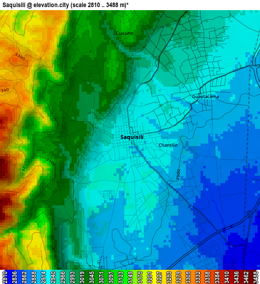
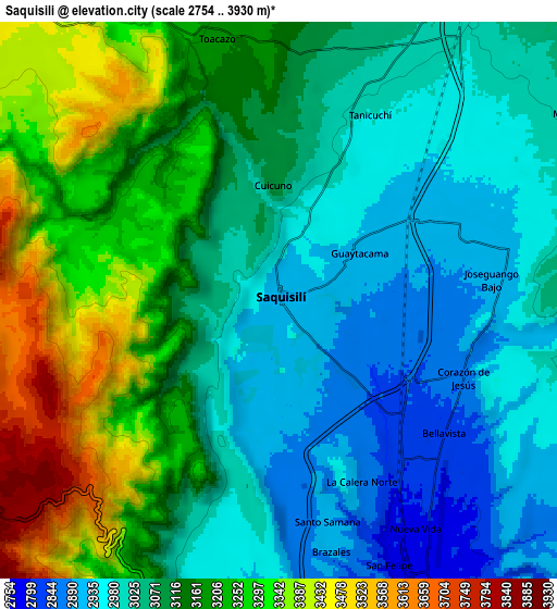
Below is the Elevation map of Saquisilí, which displays elevation range with different colors. Scale of the first map is from 2810 to 3488 m (9219 to 11444 ft) with average elevation of 2997.7 meters (=9835 ft) [note 1]
These maps also provides idea of topography and contour of this city, they are displayed at different zoom levels. More info about maps, scale and edge coordinates you can find below images.
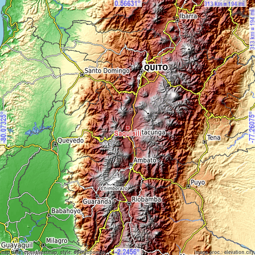
| \ | Map #1 | Map #2 | Topo.Map |
| Scale [m] | 2810..3488 m | 2754..3930 m | × |
| Scale [ft] | 9219..11444 ft | 9035..12894 ft | × |
| Average | 2997.7 m = 9835 ft | 3112.8 m = 10213 ft | × |
| Width | 9.77 km = 6.1 mi | 19.54 km = 12.1 mi | 312.7 km = 194.3 mi |
| Height | 9.77 km = 6.1 mi | 19.54 km = 12.1 mi | 312.7 km = 194.3 mi |
| ↑Max Latitude | -0.795959° | -0.752018° | 0.56631° |
| Latitude at center | -0.8399° | -0.8399° | -0.8399° |
| ↓Min Latitude | -0.88384° | -0.92778° | -2.2456° |
| ← Min Longitude | -78.710945° | -78.754891° | -80.07325° |
| Longitude center | -78.667° | -78.667° | -78.667° |
| →Max Longitude | -78.623055° | -78.579109° | -77.26075° |
Nearby cities:
Cities around Saquisilí sort by population:
• Quito elevation 2854 m
69.6 km,  13°
13°
• Ambato 2597 m
45.8 km,  172°
172°
• Latacunga 2769 m
12 km,  151°
151°
• Machachi 2933 m
38.3 km,  16°
16°
• Pelileo 2589 m
56.2 km, 165°
• La Maná 212 m
63.1 km,  259°
259°
• Pujilí 2944 m
13.5 km,  194°
194°
• San Miguel de Salcedo 2650 m
24.4 km,  159°
159°
• Baños 1805 m
67.6 km, 156°
• Píllaro 2787 m
39.5 km, 160°
• Sangolquí 2513 m
61.1 km, 23°
• Quero 2962 m
60.5 km, 173°
Multilingual:
 En español:
Saquisilí elevación 2919 m.
 En France:
Saquisilí élévation 2919 m.
 Auf Deutsch:
Saquisilí höhe über dem Meeresspiegel ist 2919 m.

Sources and notes:
- [note 1] Map square and city borders are not equal. Map elevation data is calculated only from area inside that square.
- [src 1] Elevation data from geonames database provided with same terms of usage.
- [src 2] The elevation map of Saquisilí is generated using elevation data from NASA's 3 arcsec (90m) resolution SRTM data.
- [src 3] Base (background) map © OpenStreetMap contributors tiles are generated by Geofabrik and OpenTopoMap.
Copyright & License:
This Saquisilí Elevation Map is licensed under CC BY-SA. You may reuse any part from this page, if you give a proper credit by linking to this URL:
 More info on terms of use page.