Cabrera elevation
Cabrera (María Trinidad Sánchez), Dominican Republic elevation is 22 meters and Cabrera elevation in feet is 72 ft above sea level [src 1]. Cabrera is a populated place (feature code) with elevation that is 141 meters (463 ft) smaller than average city elevation in Dominican Republic.
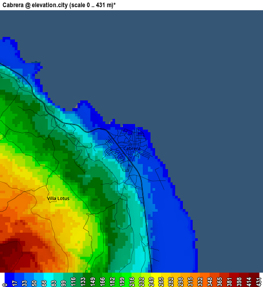
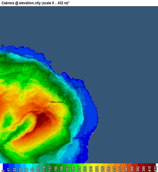
Below is the Elevation map of Cabrera, which displays elevation range with different colors. Scale of the first map is from 0 to 431 m (0 to 1414 ft) with average elevation of 152.6 meters (=501 ft) [note 1]
These maps also provides idea of topography and contour of this city, they are displayed at different zoom levels. More info about maps, scale and edge coordinates you can find below images.
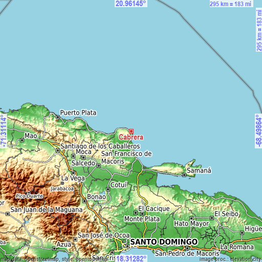
| \ | Map #1 | Map #2 | Topo.Map |
| Scale [m] | 0..431 m | 0..432 m | × |
| Scale [ft] | 0..1414 ft | 0..1417 ft | × |
| Average | 152.6 m = 501 ft | 178.9 m = 587 ft | × |
| Width | 9.2 km = 5.7 mi | 18.41 km = 11.4 mi | 294.5 km = 183 mi |
| Height | 9.2 km = 5.7 mi | 18.41 km = 11.4 mi | 294.5 km = 183 mi |
| ↑Max Latitude | 19.683983° | 19.725355° | 20.96145° |
| Latitude at center | 19.6426° | 19.6426° | 19.6426° |
| ↓Min Latitude | 19.601207° | 19.559803° | 18.31282° |
| ← Min Longitude | -69.948835° | -69.992781° | -71.31114° |
| Longitude center | -69.90489° | -69.90489° | -69.90489° |
| →Max Longitude | -69.860945° | -69.816999° | -68.49864° |
Nearby cities:
Cities around Cabrera sort by population:
• San Francisco de Macorís elevation 121 m
52.6 km,  223°
223°
• Nagua 9 m
29.5 km,  168°
168°
• Río San Juan 6 m
18 km,  270°
270°
• El Factor 20 m
36.1 km,  177°
177°
• Gaspar Hernández 13 m
39.1 km, 267°
• Castillo 80 m
50 km,  194°
194°
• Veragua Arriba 108 m
45.4 km,  261°
261°
• Villa Riva 29 m
51.4 km, 180°
• Arenoso 18 m
50.8 km, 174°
• Arroyo Salado 6 m
15.9 km, 178°
• Joba Arriba 103 m
38.8 km, 257°
• La Entrada 10 m
9.9 km, 181°
Multilingual:
 En español:
Cabrera elevación 22 m.
 En France:
Cabrera élévation 22 m.


Sources and notes:
- [note 1] Map square and city borders are not equal. Map elevation data is calculated only from area inside that square.
- [src 1] Elevation data from geonames database provided with same terms of usage.
- [src 2] The elevation map of Cabrera is generated using elevation data from NASA's 3 arcsec (90m) resolution SRTM data.
- [src 3] Base (background) map © OpenStreetMap contributors tiles are generated by Geofabrik and OpenTopoMap.
Copyright & License:
This Cabrera Elevation Map is licensed under CC BY-SA. You may reuse any part from this page, if you give a proper credit by linking to this URL:
 More info on terms of use page.