Veragua Arriba elevation
Veragua Arriba (Espaillat, Gaspar Hernández), Dominican Republic elevation is 108 meters and Veragua Arriba elevation in feet is 354 ft above sea level [src 1]. Veragua Arriba is a populated place (feature code) with elevation that is 55 meters (180 ft) smaller than average city elevation in Dominican Republic.
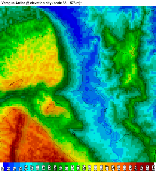
Below is the Elevation map of Veragua Arriba, which displays elevation range with different colors. Scale of the first map is from 33 to 573 m (108 to 1880 ft) with average elevation of 229.9 meters (=754 ft) [note 1]
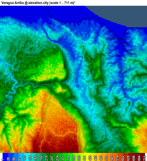
These maps also provides idea of topography and contour of this city, they are displayed at different zoom levels. More info about maps, scale and edge coordinates you can find below images.
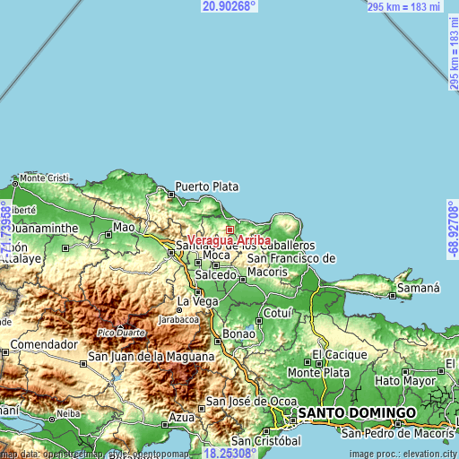
| \ | Map #1 | Map #2 | Topo.Map |
| Scale [m] | 33..573 m | 1..711 m | × |
| Scale [ft] | 108..1880 ft | 3..2333 ft | × |
| Average | 229.9 m = 754 ft | 225.3 m = 739 ft | × |
| Width | 9.21 km = 5.7 mi | 18.41 km = 11.4 mi | 294.6 km = 183.1 mi |
| Height | 9.21 km = 5.7 mi | 18.41 km = 11.4 mi | 294.6 km = 183.1 mi |
| ↑Max Latitude | 19.624728° | 19.666115° | 20.90268° |
| Latitude at center | 19.58333° | 19.58333° | 19.58333° |
| ↓Min Latitude | 19.541921° | 19.500502° | 18.25308° |
| ← Min Longitude | -70.377275° | -70.421221° | -71.73958° |
| Longitude center | -70.33333° | -70.33333° | -70.33333° |
| →Max Longitude | -70.289385° | -70.245439° | -68.92708° |
Nearby cities:
Cities around Veragua Arriba sort by population:
• Moca elevation 191 m
29.2 km,  223°
223°
• Salcedo 196 m
24.5 km,  201°
201°
• Salsipuedes 252 m
20.4 km,  193°
193°
• Río San Juan 6 m
27.7 km,  75°
75°
• Sosúa 27 m
27.1 km,  313°
313°
• Tenares 173 m
23.3 km,  184°
184°
• Gaspar Hernández 13 m
7.6 km,  49°
49°
• San Víctor Arriba 530 m
24.3 km,  240°
240°
• Cabarete 12 m
20.1 km,  337°
337°
• Jamao al Norte 51 m
13.2 km,  296°
296°
• Juan López Abajo 254 m
24.2 km,  226°
226°
• Joba Arriba 103 m
7.2 km,  104°
104°
Multilingual:
 En español:
Veragua Arriba elevación 108 m.
 En France:
Veragua Arriba élévation 108 m.
 Auf Deutsch:
Veragua Arriba höhe über dem Meeresspiegel ist 108 m.

Sources and notes:
- [note 1] Map square and city borders are not equal. Map elevation data is calculated only from area inside that square.
- [src 1] Elevation data from geonames database provided with same terms of usage.
- [src 2] The elevation map of Veragua Arriba is generated using elevation data from NASA's 3 arcsec (90m) resolution SRTM data.
- [src 3] Base (background) map © OpenStreetMap contributors tiles are generated by Geofabrik and OpenTopoMap.
Copyright & License:
This Veragua Arriba Elevation Map is licensed under CC BY-SA. You may reuse any part from this page, if you give a proper credit by linking to this URL:
 More info on terms of use page.