Salcedo elevation
Salcedo (Hermanas Mirabal), Dominican Republic elevation is 196 meters and Salcedo elevation in feet is 643 ft above sea level [src 1]. Salcedo is a seat of a first-order administrative division (feature code) with elevation that is 33 meters (108 ft) bigger than average city elevation in Dominican Republic.
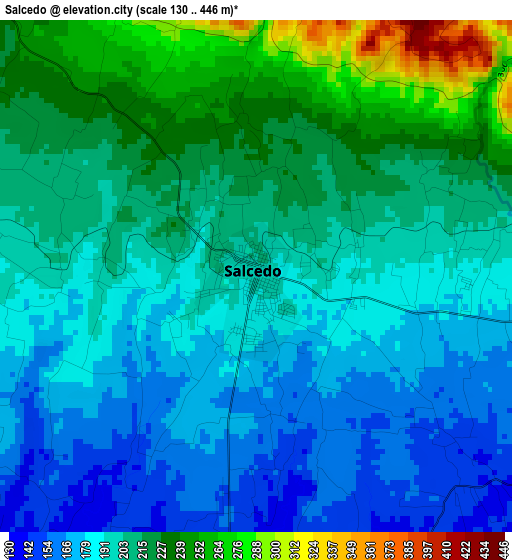
Below is the Elevation map of Salcedo, which displays elevation range with different colors. Scale of the first map is from 130 to 446 m (427 to 1463 ft) with average elevation of 202 meters (=663 ft) [note 1]
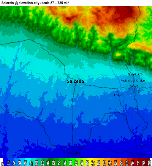
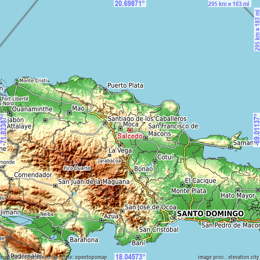
These maps also provides idea of topography and contour of this city, they are displayed at different zoom levels. More info about maps, scale and edge coordinates you can find below images.
| \ | Map #1 | Map #2 | Topo.Map |
| Scale [m] | 130..446 m | 87..785 m | × |
| Scale [ft] | 427..1463 ft | 285..2575 ft | × |
| Average | 202 m = 663 ft | 245.5 m = 805 ft | × |
| Width | 9.22 km = 5.7 mi | 18.44 km = 11.5 mi | 295 km = 183.3 mi |
| Height | 9.22 km = 5.7 mi | 18.44 km = 11.5 mi | 295 km = 183.3 mi |
| ↑Max Latitude | 19.419071° | 19.460511° | 20.69871° |
| Latitude at center | 19.37762° | 19.37762° | 19.37762° |
| ↓Min Latitude | 19.336159° | 19.294687° | 18.04573° |
| ← Min Longitude | -70.461565° | -70.505511° | -71.82387° |
| Longitude center | -70.41762° | -70.41762° | -70.41762° |
| →Max Longitude | -70.373675° | -70.329729° | -69.01137° |
Nearby cities:
Cities around Salcedo sort by population:
• San Francisco de Macorís elevation 121 m
19.3 km,  116°
116°
• Concepción de La Vega 101 m
20.9 km,  214°
214°
• Moca 191 m
11.5 km,  278°
278°
• Tamboril 266 m
23.6 km,  300°
300°
• Salsipuedes 252 m
5 km,  51°
51°
• Tenares 173 m
7 km,  92°
92°
• Licey al Medio 199 m
20.1 km,  287°
287°
• San Víctor Arriba 530 m
16.6 km,  311°
311°
• Río Verde Arriba 169 m
17.1 km,  246°
246°
• Villa Tapia 107 m
8.5 km,  183°
183°
• Cayetano Germosén 150 m
7.8 km,  241°
241°
• Juan López Abajo 254 m
10.6 km, 305°
Multilingual:
 En español:
Salcedo elevación 196 m.
 En France:
Salcedo élévation 196 m.


Sources and notes:
- [note 1] Map square and city borders are not equal. Map elevation data is calculated only from area inside that square.
- [src 1] Elevation data from geonames database provided with same terms of usage.
- [src 2] The elevation map of Salcedo is generated using elevation data from NASA's 3 arcsec (90m) resolution SRTM data.
- [src 3] Base (background) map © OpenStreetMap contributors tiles are generated by Geofabrik and OpenTopoMap.
Copyright & License:
This Salcedo Elevation Map is licensed under CC BY-SA. You may reuse any part from this page, if you give a proper credit by linking to this URL:
 More info on terms of use page.