Nagua elevation
Nagua (María Trinidad Sánchez), Dominican Republic elevation is 9 meters and Nagua elevation in feet is 30 ft above sea level [src 1]. Nagua is a seat of a first-order administrative division (feature code) with elevation that is 154 meters (505 ft) smaller than average city elevation in Dominican Republic.
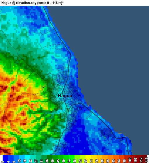
Below is the Elevation map of Nagua, which displays elevation range with different colors. Scale of the first map is from 0 to 116 m (0 to 381 ft) with average elevation of 33.8 meters (=111 ft) [note 1]
These maps also provides idea of topography and contour of this city, they are displayed at different zoom levels. More info about maps, scale and edge coordinates you can find below images.
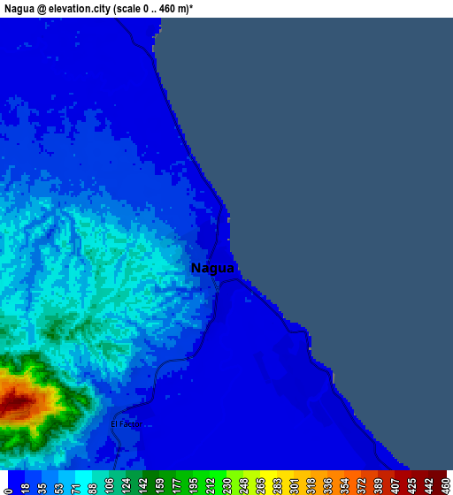
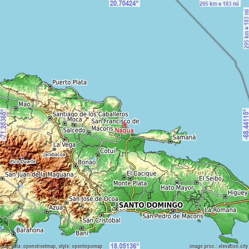
| \ | Map #1 | Map #2 | Topo.Map |
| Scale [m] | 0..116 m | 0..460 m | × |
| Scale [ft] | 0..381 ft | 0..1509 ft | × |
| Average | 33.8 m = 111 ft | 43.3 m = 142 ft | × |
| Width | 9.22 km = 5.7 mi | 18.44 km = 11.5 mi | 295 km = 183.3 mi |
| Height | 9.22 km = 5.7 mi | 18.44 km = 11.5 mi | 295 km = 183.3 mi |
| ↑Max Latitude | 19.424649° | 19.466088° | 20.70424° |
| Latitude at center | 19.3832° | 19.3832° | 19.3832° |
| ↓Min Latitude | 19.34174° | 19.30027° | 18.05136° |
| ← Min Longitude | -69.891345° | -69.935291° | -71.25365° |
| Longitude center | -69.8474° | -69.8474° | -69.8474° |
| →Max Longitude | -69.803455° | -69.759509° | -68.44115° |
Nearby cities:
Cities around Nagua sort by population:
• Sánchez elevation 25 m
30 km,  125°
125°
• Pimentel 42 m
35.3 km,  231°
231°
• Las Terrenas 17 m
32.9 km,  104°
104°
• El Factor 20 m
8.4 km,  210°
210°
• Castillo 80 m
27.1 km,  224°
224°
• Villa Riva 29 m
23.6 km,  197°
197°
• Cabrera 22 m
29.5 km,  348°
348°
• Arenoso 18 m
21.8 km,  183°
183°
• Arroyo Salado 6 m
14.1 km,  336°
336°
• Agua Santa del Yuna 11 m
26.3 km,  169°
169°
• Hostos 48 m
29 km, 218°
• La Entrada 10 m
20 km, 341°
Multilingual:
 En español:
Nagua elevación 9 m.
 En France:
Nagua élévation 9 m.


Sources and notes:
- [note 1] Map square and city borders are not equal. Map elevation data is calculated only from area inside that square.
- [src 1] Elevation data from geonames database provided with same terms of usage.
- [src 2] The elevation map of Nagua is generated using elevation data from NASA's 3 arcsec (90m) resolution SRTM data.
- [src 3] Base (background) map © OpenStreetMap contributors tiles are generated by Geofabrik and OpenTopoMap.
Copyright & License:
This Nagua Elevation Map is licensed under CC BY-SA. You may reuse any part from this page, if you give a proper credit by linking to this URL:
 More info on terms of use page.