Flöthe elevation
Flöthe (Lower Saxony), Germany elevation is 118 meters and Flöthe elevation in feet is 387 ft above sea level [src 1]. Flöthe is a seat of a fourth-order administrative division (feature code) with elevation that is 140 meters (459 ft) smaller than average city elevation in Germany.
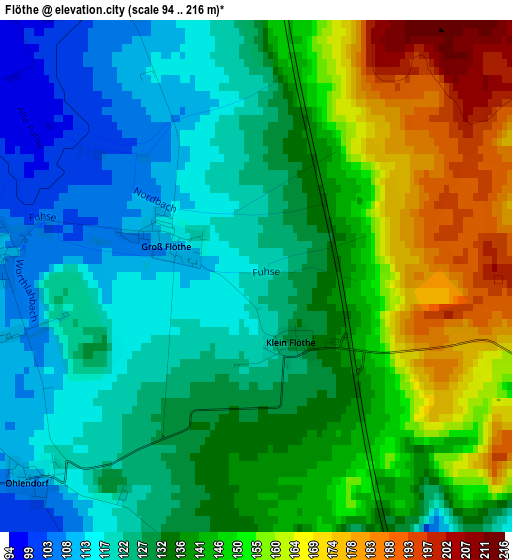
Below is the Elevation map of Flöthe, which displays elevation range with different colors. Scale of the first map is from 94 to 216 m (308 to 709 ft) with average elevation of 136.7 meters (=448 ft) [note 1]
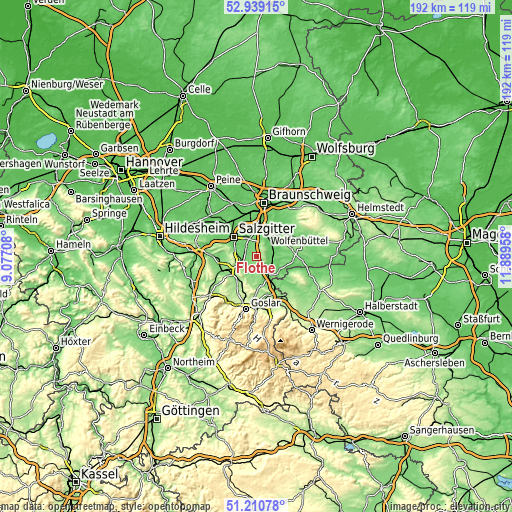
These maps also provides idea of topography and contour of this city, they are displayed at different zoom levels. More info about maps, scale and edge coordinates you can find below images.
| \ | Map #1 | Topo.Map |
| Scale [m] | 94..216 m | × |
| Scale [ft] | 308..709 ft | × |
| Average | 136.7 m = 448 ft | × |
| Width | 6.01 km = 3.7 mi | 192.2 km = 119.4 mi |
| Height | 6.01 km = 3.7 mi | 192.2 km = 119.4 mi |
| ↑Max Latitude | 52.110327° | 52.93915° |
| Latitude at center | 52.08333° | 52.08333° |
| ↓Min Latitude | 52.056317° | 51.21078° |
| ← Min Longitude | 10.439385° | 9.07708° |
| Longitude center | 10.48333° | 10.48333° |
| →Max Longitude | 10.527275° | 11.88958° |
Nearby cities:
Cities around Flöthe sort by population:
• Salzgitter elevation 99 m
9.4 km,  330°
330°
• Wolfenbüttel 80 m
9.8 km,  23°
23°
• Liebenburg 132 m
7.7 km,  207°
207°
• Schladen 98 m
7.8 km,  150°
150°
• Leiferde 76 m
13.6 km,  7°
7°
• Hornburg 92 m
10.1 km,  125°
125°
• Börßum 91 m
7.1 km,  102°
102°
• Remlingen 137 m
13.5 km,  75°
75°
• Kissenbrück 84 m
7.8 km,  68°
68°
• Elbe 111 m
13.7 km,  270°
270°
• Wittmar 122 m
11.9 km,  64°
64°
• Alt Wallmoden 136 m
14.2 km,  240°
240°
Multilingual:
 En español:
Flöthe elevación 118 m.
 En France:
Flöthe élévation 118 m.


Sources and notes:
- [note 1] Map square and city borders are not equal. Map elevation data is calculated only from area inside that square.
- [src 1] Elevation data from geonames database provided with same terms of usage.
- [src 2] The elevation map of Flöthe is generated using elevation data from NASA's 3 arcsec (90m) resolution SRTM data.
- [src 3] Base (background) map © OpenStreetMap contributors tiles are generated by Geofabrik and OpenTopoMap.
Copyright & License:
This Flöthe Elevation Map is licensed under CC BY-SA. You may reuse any part from this page, if you give a proper credit by linking to this URL:
 More info on terms of use page.