Salzgitter elevation
Salzgitter (Lower Saxony), Germany elevation is 99 meters and Salzgitter elevation in feet is 325 ft above sea level [src 1]. Salzgitter is a populated place (feature code) with elevation that is 159 meters (522 ft) smaller than average city elevation in Germany.
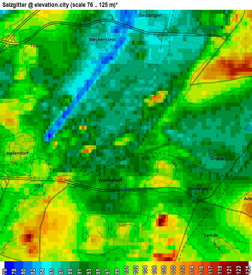
Below is the Elevation map of Salzgitter, which displays elevation range with different colors. Scale of the first map is from 76 to 125 m (249 to 410 ft) with average elevation of 96.1 meters (=315 ft) [note 1]
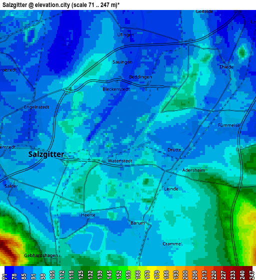
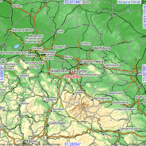
These maps also provides idea of topography and contour of this city, they are displayed at different zoom levels. More info about maps, scale and edge coordinates you can find below images.
| \ | Map #1 | Map #2 | Topo.Map |
| Scale [m] | 76..125 m | 71..247 m | × |
| Scale [ft] | 249..410 ft | 233..810 ft | × |
| Average | 96.1 m = 315 ft | 98.3 m = 323 ft | × |
| Width | 6 km = 3.7 mi | 11.99 km = 7.5 mi | 191.9 km = 119.2 mi |
| Height | 6 km = 3.7 mi | 11.99 km = 7.5 mi | 191.8 km = 119.2 mi |
| ↑Max Latitude | 52.184002° | 52.210938° | 53.01144° |
| Latitude at center | 52.15705° | 52.15705° | 52.15705° |
| ↓Min Latitude | 52.130081° | 52.103097° | 51.28594° |
| ← Min Longitude | 10.371455° | 10.327509° | 9.00915° |
| Longitude center | 10.4154° | 10.4154° | 10.4154° |
| →Max Longitude | 10.459345° | 10.503291° | 11.82165° |
Nearby cities:
Cities around Salzgitter sort by population:
• Braunschweig elevation 72 m
14.3 km,  32°
32°
• Wolfenbüttel 80 m
8.6 km,  84°
84°
• Vechelde 82 m
12 km,  343°
343°
• Lengede 82 m
9.1 km,  305°
305°
• Liebenburg 132 m
15.1 km,  175°
175°
• Söhlde 99 m
13 km,  285°
285°
• Leiferde 76 m
8.2 km,  50°
50°
• Baddeckenstedt 110 m
14.9 km,  236°
236°
• Börßum 91 m
15.1 km,  130°
130°
• Kissenbrück 84 m
13 km,  113°
113°
• Elbe 111 m
12.2 km,  227°
227°
• Flöthe 118 m
9.4 km,  150°
150°
Multilingual:
 En español:
Salzgitter elevación 99 m.
 En France:
Salzgitter élévation 99 m.
 Auf Deutsch:
Salzgitter höhe über dem Meeresspiegel ist 99 m.

Sources and notes:
- [note 1] Map square and city borders are not equal. Map elevation data is calculated only from area inside that square.
- [src 1] Elevation data from geonames database provided with same terms of usage.
- [src 2] The elevation map of Salzgitter is generated using elevation data from NASA's 3 arcsec (90m) resolution SRTM data.
- [src 3] Base (background) map © OpenStreetMap contributors tiles are generated by Geofabrik and OpenTopoMap.
Copyright & License:
This Salzgitter Elevation Map is licensed under CC BY-SA. You may reuse any part from this page, if you give a proper credit by linking to this URL:
 More info on terms of use page.