Allstedt elevation
Allstedt (Saxony-Anhalt), Germany elevation is 135 meters and Allstedt elevation in feet is 443 ft above sea level [src 1]. Allstedt is a populated place (feature code) with elevation that is 123 meters (404 ft) smaller than average city elevation in Germany.
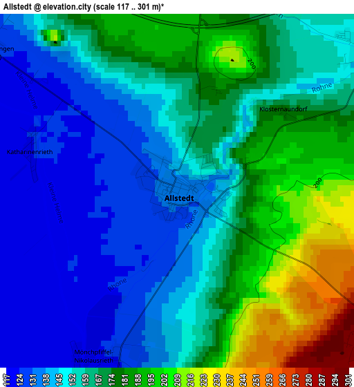
Below is the Elevation map of Allstedt, which displays elevation range with different colors. Scale of the first map is from 117 to 301 m (384 to 988 ft) with average elevation of 161.9 meters (=531 ft) [note 1]
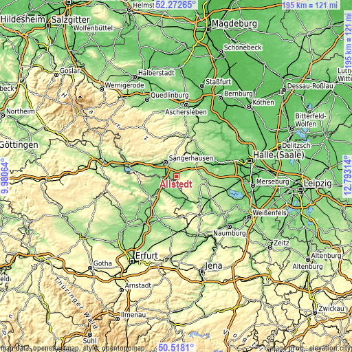
These maps also provides idea of topography and contour of this city, they are displayed at different zoom levels. More info about maps, scale and edge coordinates you can find below images.
| \ | Map #1 | Topo.Map |
| Scale [m] | 117..301 m | × |
| Scale [ft] | 384..988 ft | × |
| Average | 161.9 m = 531 ft | × |
| Width | 6.1 km = 3.8 mi | 195.1 km = 121.2 mi |
| Height | 6.1 km = 3.8 mi | 195.1 km = 121.2 mi |
| ↑Max Latitude | 51.431196° | 52.27265° |
| Latitude at center | 51.40379° | 51.40379° |
| ↓Min Latitude | 51.376367° | 50.5181° |
| ← Min Longitude | 11.342945° | 9.98064° |
| Longitude center | 11.38689° | 11.38689° |
| →Max Longitude | 11.430835° | 12.79314° |
Nearby cities:
Cities around Allstedt sort by population:
• Sangerhausen elevation 154 m
9.9 km,  320°
320°
• Artern 127 m
7.9 km,  236°
236°
• Roßleben 131 m
12.1 km,  164°
164°
• Wallhausen 144 m
14 km,  297°
297°
• Oberröblingen 130 m
6.6 km, 303°
• Riestedt 177 m
10.3 km,  349°
349°
• Blankenheim 297 m
11.9 km,  14°
14°
• Farnstädt 185 m
12.9 km,  75°
75°
• Edersleben 143 m
7.3 km,  281°
281°
• Osterhausen 165 m
9.9 km,  55°
55°
• Voigtstedt 128 m
5.6 km,  256°
256°
• Ringleben 127 m
12.5 km,  250°
250°
Multilingual:
 En español:
Allstedt elevación 135 m.
 En France:
Allstedt élévation 135 m.
 Auf Deutsch:
Allstedt höhe über dem Meeresspiegel ist 135 m.

Sources and notes:
- [note 1] Map square and city borders are not equal. Map elevation data is calculated only from area inside that square.
- [src 1] Elevation data from geonames database provided with same terms of usage.
- [src 2] The elevation map of Allstedt is generated using elevation data from NASA's 3 arcsec (90m) resolution SRTM data.
- [src 3] Base (background) map © OpenStreetMap contributors tiles are generated by Geofabrik and OpenTopoMap.
Copyright & License:
This Allstedt Elevation Map is licensed under CC BY-SA. You may reuse any part from this page, if you give a proper credit by linking to this URL:
 More info on terms of use page.