Ringleben elevation
Ringleben (Thuringia), Germany elevation is 127 meters and Ringleben elevation in feet is 417 ft above sea level [src 1]. Ringleben is a seat of a fourth-order administrative division (feature code) with elevation that is 131 meters (430 ft) smaller than average city elevation in Germany.
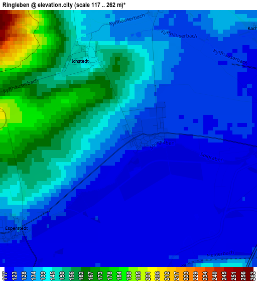
Below is the Elevation map of Ringleben, which displays elevation range with different colors. Scale of the first map is from 117 to 262 m (384 to 860 ft) with average elevation of 136.9 meters (=449 ft) [note 1]
These maps also provides idea of topography and contour of this city, they are displayed at different zoom levels. More info about maps, scale and edge coordinates you can find below images.
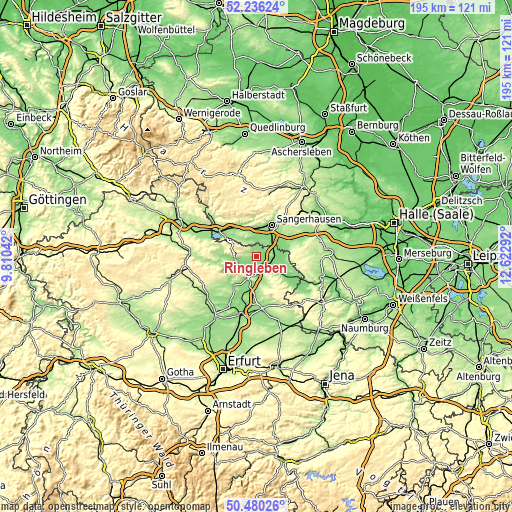
| \ | Map #1 | Topo.Map |
| Scale [m] | 117..262 m | × |
| Scale [ft] | 384..860 ft | × |
| Average | 136.9 m = 449 ft | × |
| Width | 6.1 km = 3.8 mi | 195.2 km = 121.3 mi |
| Height | 6.1 km = 3.8 mi | 195.2 km = 121.3 mi |
| ↑Max Latitude | 51.394098° | 52.23624° |
| Latitude at center | 51.36667° | 51.36667° |
| ↓Min Latitude | 51.339225° | 50.48026° |
| ← Min Longitude | 11.172725° | 9.81042° |
| Longitude center | 11.21667° | 11.21667° |
| →Max Longitude | 11.260615° | 12.62292° |
Nearby cities:
Cities around Ringleben sort by population:
• Sangerhausen elevation 154 m
12.9 km,  24°
24°
• Bad Frankenhausen 137 m
8.2 km,  261°
261°
• Artern 127 m
5.2 km,  92°
92°
• Allstedt 135 m
12.5 km,  70°
70°
• Oldisleben 132 m
7.1 km,  206°
206°
• Heldrungen 129 m
7.2 km,  179°
179°
• Wallhausen 144 m
10.5 km,  356°
356°
• Oberröblingen 130 m
10 km,  38°
38°
• Edersleben 143 m
7.2 km, 39°
• Voigtstedt 128 m
7 km, 66°
• Kannawurf 130 m
12.5 km, 207°
• Bennungen 148 m
12.5 km,  326°
326°
Multilingual:
 En español:
Ringleben elevación 127 m.
 En France:
Ringleben élévation 127 m.
 Auf Deutsch:
Ringleben höhe über dem Meeresspiegel ist 127 m.

Sources and notes:
- [note 1] Map square and city borders are not equal. Map elevation data is calculated only from area inside that square.
- [src 1] Elevation data from geonames database provided with same terms of usage.
- [src 2] The elevation map of Ringleben is generated using elevation data from NASA's 3 arcsec (90m) resolution SRTM data.
- [src 3] Base (background) map © OpenStreetMap contributors tiles are generated by Geofabrik and OpenTopoMap.
Copyright & License:
This Ringleben Elevation Map is licensed under CC BY-SA. You may reuse any part from this page, if you give a proper credit by linking to this URL:
 More info on terms of use page.