Brunn elevation
Brunn (Bavaria, Upper Palatinate), Germany elevation is 463 meters and Brunn elevation in feet is 1519 ft above sea level [src 1]. Brunn is a populated place (feature code) with elevation that is 205 meters (673 ft) bigger than average city elevation in Germany.
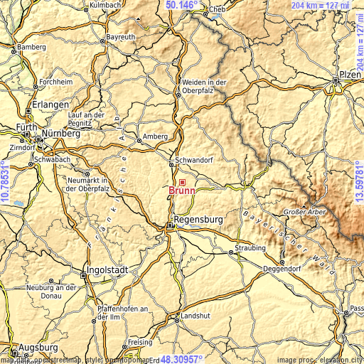
Below is the Elevation map of Brunn, which displays elevation range with different colors. Scale of the first map is from 341 to 574 m (1119 to 1883 ft) with average elevation of 430.1 meters (=1411 ft) [note 1]
These maps also provides idea of topography and contour of this city, they are displayed at different zoom levels. More info about maps, scale and edge coordinates you can find below images.

| \ | Map #1 | Topo.Map |
| Scale [m] | 341..574 m | × |
| Scale [ft] | 1119..1883 ft | × |
| Average | 430.1 m = 1411 ft | × |
| Width | 6.38 km = 4 mi | 204.2 km = 126.9 mi |
| Height | 6.38 km = 4 mi | 204.2 km = 126.9 mi |
| ↑Max Latitude | 49.265005° | 50.146° |
| Latitude at center | 49.23632° | 49.23632° |
| ↓Min Latitude | 49.207618° | 48.30957° |
| ← Min Longitude | 12.147615° | 10.78531° |
| Longitude center | 12.19156° | 12.19156° |
| →Max Longitude | 12.235505° | 13.59781° |
Nearby cities:
Cities around Brunn sort by population:
• Schwandorf in Bayern elevation 363 m
11.5 km,  329°
329°
• Regenstauf 353 m
13.7 km,  199°
199°
• Burglengenfeld 368 m
11.3 km,  251°
251°
• Maxhütte-Haidhof 421 m
8.3 km,  240°
240°
• Nittenau 353 m
7.2 km,  130°
130°
• Teublitz 355 m
7.7 km,  258°
258°
• Wackersdorf 452 m
9 km,  356°
356°
• Bruck in der Oberpfalz 371 m
8.5 km,  80°
80°
• Bodenwöhr 390 m
8.9 km,  64°
64°
• Wald 552 m
15 km, 129°
• Tiefenbach 355 m
11.1 km,  120°
120°
• Reichenbach 372 m
12.9 km, 117°
Multilingual:
 En español:
Brunn elevación 463 m.
 En France:
Brunn élévation 463 m.


Sources and notes:
- [note 1] Map square and city borders are not equal. Map elevation data is calculated only from area inside that square.
- [src 1] Elevation data from geonames database provided with same terms of usage.
- [src 2] The elevation map of Brunn is generated using elevation data from NASA's 3 arcsec (90m) resolution SRTM data.
- [src 3] Base (background) map © OpenStreetMap contributors tiles are generated by Geofabrik and OpenTopoMap.
Copyright & License:
This Brunn Elevation Map is licensed under CC BY-SA. You may reuse any part from this page, if you give a proper credit by linking to this URL:
 More info on terms of use page.