Schwandorf in Bayern elevation
Schwandorf in Bayern (Bavaria, Upper Palatinate), Germany elevation is 363 meters and Schwandorf in Bayern elevation in feet is 1191 ft above sea level [src 1]. Schwandorf in Bayern is a seat of a third-order administrative division (feature code) with elevation that is 105 meters (344 ft) bigger than average city elevation in Germany.
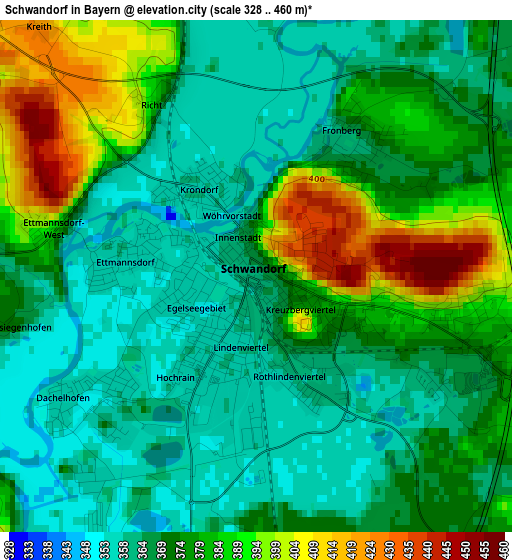
Below is the Elevation map of Schwandorf in Bayern, which displays elevation range with different colors. Scale of the first map is from 328 to 460 m (1076 to 1509 ft) with average elevation of 373.7 meters (=1226 ft) [note 1]
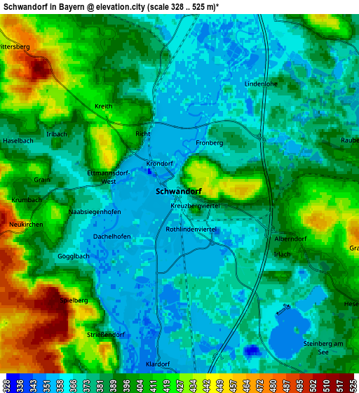
These maps also provides idea of topography and contour of this city, they are displayed at different zoom levels. More info about maps, scale and edge coordinates you can find below images.
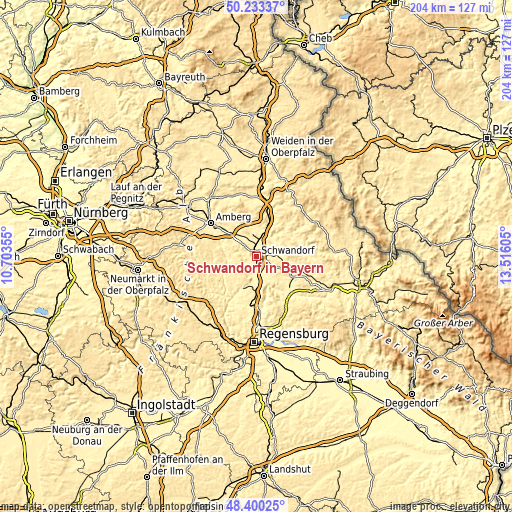
| \ | Map #1 | Map #2 | Topo.Map |
| Scale [m] | 328..460 m | 328..525 m | × |
| Scale [ft] | 1076..1509 ft | 1076..1722 ft | × |
| Average | 373.7 m = 1226 ft | 389.9 m = 1279 ft | × |
| Width | 6.37 km = 4 mi | 12.74 km = 7.9 mi | 203.8 km = 126.6 mi |
| Height | 6.37 km = 4 mi | 12.74 km = 7.9 mi | 203.8 km = 126.6 mi |
| ↑Max Latitude | 49.353974° | 49.382591° | 50.23337° |
| Latitude at center | 49.32534° | 49.32534° | 49.32534° |
| ↓Min Latitude | 49.29669° | 49.268023° | 48.40025° |
| ← Min Longitude | 12.065855° | 12.021909° | 10.70355° |
| Longitude center | 12.1098° | 12.1098° | 12.1098° |
| →Max Longitude | 12.153745° | 12.197691° | 13.51605° |
Nearby cities:
Cities around Schwandorf in Bayern sort by population:
• Burglengenfeld elevation 368 m
14.3 km,  199°
199°
• Maxhütte-Haidhof 421 m
14 km,  185°
185°
• Teublitz 355 m
11.5 km, 188°
• Schwarzenfeld 364 m
7.2 km,  14°
14°
• Wackersdorf 452 m
5.4 km,  100°
100°
• Breitenbrunn 410 m
7.8 km,  303°
303°
• Rieden 365 m
12.2 km,  269°
269°
• Schmidgaden 382 m
11 km,  353°
353°
• Ebermannsdorf 409 m
14.7 km, 301°
• Ensdorf 373 m
12.7 km,  277°
277°
• Stulln 369 m
10.3 km, 9°
• Brunn 463 m
11.5 km,  149°
149°
Multilingual:
 En español:
Schwandorf in Bayern elevación 363 m.
 En France:
Schwandorf in Bayern élévation 363 m.
 Auf Deutsch:
Schwandorf in Bayern höhe über dem Meeresspiegel ist 363 m.
 На русском:
Schwandorf in Bayern высота над уровнем моря 363 м
Sources and notes:
- [note 1] Map square and city borders are not equal. Map elevation data is calculated only from area inside that square.
- [src 1] Elevation data from geonames database provided with same terms of usage.
- [src 2] The elevation map of Schwandorf in Bayern is generated using elevation data from NASA's 3 arcsec (90m) resolution SRTM data.
- [src 3] Base (background) map © OpenStreetMap contributors tiles are generated by Geofabrik and OpenTopoMap.
Copyright & License:
This Schwandorf in Bayern Elevation Map is licensed under CC BY-SA. You may reuse any part from this page, if you give a proper credit by linking to this URL:
 More info on terms of use page.